Squinzano geodata
Squinzano (Apulia) is a seat of a third-order administrative division; located in Italy in Europe/Rome (GMT+2) time zone. With population of 14,482 people, there are 626 cities with bigger population in this country. Compared to other cities in Italy, 84.5% of cities are located further ↑North; 99% of cities are located further ←West and 80.5% of cities have higher elevation than Squinzano. Note1


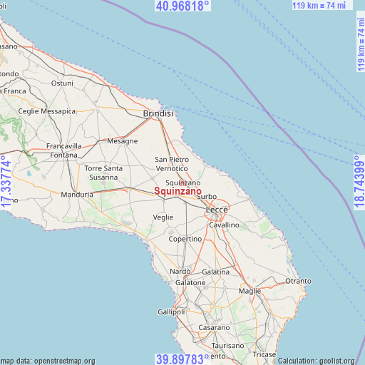
Squinzano GPS coordinates[2]
40° 26' 6.468" North, 18° 2' 27.096" East
| Map corner | latitude | longitude |
|---|---|---|
| Upper-left | 40.96818°, | 17.33774° |
| Center: | 40.43513°, | 18.04086° |
| Lower-right: | 39.89783°, | 18.74399° |
| Map W x H: | 119×119 km | = 73.9×73.9mi |
| max Lat: | 47.04031° ⇑84.5% North |
| Squinzano: | 40.43513° |
| min Lat: | ⇓15.5% South 35.50142° |
| min Long | Squinzano | max Long |
| 6.69888° | 18.04086° | 18.48682° |
| W 99%⇐ | ⇒1% E |
Elevation
Elevation of Squinzano is 47 m = 154 ft, and this is 259.7 m = 852 ft below average elevation for this country.
| Max E: |
2085 m = 6841 ft | 80.5% |
| Avg. | 306.7 m = 1006 ft | |
| Squinzano | 47 m = 154 ft | |
Min E: |
-4 m = -13 ft | 19.5% |
See also: Italy elevation on elevation.city.
Geographical zone
Squinzano is located in North temperate zone (between Tropic of Cancer and the Arctic Circle). Distance of this Northern Tropic circle is 1890 km =1174.4 mi to South.| Distance of | km | miles | from Squinzano |
|---|---|---|---|
| North Pole | 5511.1 | 3424.4 | to North |
| Arctic Circle | 2905.2 | 1805.2 | to North |
| Tropic Cancer | 1890 | 1174.4 | to South |
| Equator | 4496 | 2793.7 | to South |


Nearby cities:
15 places around Squinzano: (largest is in red/bold)
• Campi Salentina
4.5 km =2.8 mi,  201°
201°
• Carmiano
10.1 km =6.3 mi,  179°
179°
• Cellino San Marco
7.6 km =4.7 mi,  301°
301°
• Giorgilorio
10.6 km =6.6 mi,  120°
120°
• Guagnano
8.6 km =5.3 mi,  244°
244°
• Magliano
11 km =6.8 mi,  170°
170°
• Novoli
6.5 km =4 mi, 174°
• Riesci
10.9 km =6.8 mi,  155°
155°
• Salice Salentino
8.8 km =5.5 mi,  230°
230°
• San Donaci
10.1 km =6.3 mi,  278°
278°
• San Pietro Vernotico
7 km =4.3 mi,  328°
328°
• Surbo
9.2 km =5.7 mi, 120°
• Torchiarolo
5.4 km =3.4 mi,  9°
9°
• Trepuzzi
4.5 km =2.8 mi,  137°
137°
• Villa Baldassarri
6.8 km =4.2 mi,  251°
251°
Sources, notices
• [Note1] Compared only with cities in Italy existing in our database
• [Src1] Map data: © OpenStreetMap contributors (CC-BY-SA)
• [Src2] Other city data from geonames.org with taken over terms of usage.
• [Src3] Geographical zone / Annual Mean Temperature by Robert A. Rohde @ Wikipedia
