San Pietro Vernotico geodata
San Pietro Vernotico (Apulia) is a seat of a third-order administrative division; located in Italy in Europe/Rome (GMT+2) time zone. With population of 13,667 people, there are 665 cities with bigger population in this country. Compared to other cities in Italy, 84.2% of cities are located further ↑North; 98.9% of cities are located further ←West and 82.5% of cities have higher elevation than San Pietro Vernotico. Note1
Administrative division(s):
- Level 1: Apulia
- Level 2: Provincia di Brindisi
- Level 3: San Pietro Vernotico
Current local time in San Pietro Vernotico:
09:46 AM, WednesdayDifference from your time zone: hours


San Pietro Vernotico GPS coordinates[2]
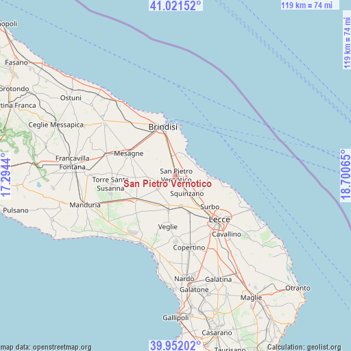
40° 29' 20.04" North, 17° 59' 51.072" East
| Map corner | latitude | longitude |
|---|---|---|
| Upper-left | 41.02152°, | 17.2944° |
| Center: | 40.4889°, | 17.99752° |
| Lower-right: | 39.95202°, | 18.70065° |
| Map W x H: | 118.9×118.9 km | = 73.9×73.9mi |
| max Lat: | 47.04031° ⇑84.2% North |
| San Pietro Vernotico: | 40.4889° |
| min Lat: | ⇓15.8% South 35.50142° |
| min Long | San Pietro Vern | max Long |
| 6.69888° | 17.99752° | 18.48682° |
| W 98.9%⇐ | ⇒1.1% E |
Elevation
Elevation of San Pietro Vernotico is 40 m = 131 ft, and this is 266.7 m = 875 ft below average elevation for this country.
| Max E: |
2085 m = 6841 ft | 82.5% |
| Avg. | 306.7 m = 1006 ft | |
| San Pietro Vernotico | 40 m = 131 ft | |
Min E: |
-4 m = -13 ft | 17.5% |
See also: Italy elevation on elevation.city.
Geographical zone
San Pietro Vernotico is located in North temperate zone (between Tropic of Cancer and the Arctic Circle). Distance of this Northern Tropic circle is 1896 km =1178.1 mi to South.| Distance of | km | miles | from San Pietro Vernotico |
|---|---|---|---|
| North Pole | 5505.1 | 3420.7 | to North |
| Arctic Circle | 2899.2 | 1801.5 | to North |
| Tropic Cancer | 1896 | 1178.1 | to South |
| Equator | 4501.9 | 2797.4 | to South |


Nearby cities:
15 places around San Pietro Vernotico: (largest is in red/bold)
• Campi Salentina
10.4 km =6.5 mi,  168°
168°
• Carmiano
16.5 km =10.3 mi, 166°
• Cellino San Marco
3.4 km =2.1 mi,  235°
235°
• Guagnano
10.6 km =6.6 mi,  202°
202°
• La Rosa
13.7 km =8.5 mi,  343°
343°
• Novoli
13.2 km =8.2 mi,  161°
161°
• Salice Salentino
12 km =7.5 mi,  194°
194°
• San Donaci
7.8 km =4.8 mi,  234°
234°
• San Pancrazio Salentino
15.9 km =9.9 mi, 240°
• Squinzano
7 km =4.3 mi,  148°
148°
• Surbo
15.7 km =9.8 mi,  132°
132°
• Torchiarolo
4.6 km =2.9 mi,  97°
97°
• Trepuzzi
11.4 km =7.1 mi,  144°
144°
• Tuturano
7.5 km =4.7 mi,  325°
325°
• Villa Baldassarri
8.6 km =5.3 mi, 198°
Sources, notices
• [Note1] Compared only with cities in Italy existing in our database
• [Src1] Map data: © OpenStreetMap contributors (CC-BY-SA)
• [Src2] Other city data from geonames.org with taken over terms of usage.
• [Src3] Geographical zone / Annual Mean Temperature by Robert A. Rohde @ Wikipedia
