Serralunga di Crea geodata
Serralunga di Crea (Piedmont) is a seat of a third-order administrative division; located in Italy in Europe/Rome (GMT+2) time zone. With population of 112 people, there are 11400 cities with bigger population in this country. Compared to other cities in Italy, 62.4% of cities are located further ↓South; 90.3% of cities are located further →East and 51.2% of cities have lower elevation than Serralunga di Crea. Note1
Administrative division(s):
- Level 1: Piedmont
- Level 2: Provincia di Alessandria
- Level 3: Serralunga di Crea


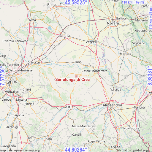
Serralunga di Crea GPS coordinates[2]
45° 6' 3.96" North, 8° 16' 50.484" East
| Map corner | latitude | longitude |
|---|---|---|
| Upper-left | 45.59525°, | 7.57756° |
| Center: | 45.1011°, | 8.28069° |
| Lower-right: | 44.60264°, | 8.98381° |
| Map W x H: | 110.4×110.4 km | = 68.6×68.6mi |
| max Lat: | 47.04031° ⇑37.6% North |
| Serralunga di Crea: | 45.1011° |
| min Lat: | ⇓62.4% South 35.50142° |
| min Long | Serralunga di C | max Long |
| 6.69888° | 8.28069° | 18.48682° |
| W 9.7%⇐ | ⇒90.3% E |
Elevation
Elevation of Serralunga di Crea is 242 m = 794 ft, and this is 64.7 m = 212 ft below average elevation for this country.
| Max E: |
2085 m = 6841 ft | 48.8% |
| Avg. | 306.7 m = 1006 ft | |
| Serralunga di Crea | 242 m = 794 ft | |
Min E: |
-4 m = -13 ft | 51.2% |
See also: Italy elevation on elevation.city.
Geographical zone
Serralunga di Crea is located in North temperate zone (between Tropic of Cancer and the Arctic Circle). Distance of this North polar circle is 2386.4 km =1482.8 mi to North.| Distance of | km | miles | from Serralunga di Crea |
|---|---|---|---|
| North Pole | 4992.3 | 3102.1 | to North |
| Arctic Circle | 2386.4 | 1482.8 | to North |
| Tropic Cancer | 2408.9 | 1496.8 | to South |
| Equator | 5014.8 | 3116.1 | to South |


Nearby cities:
15 places around Serralunga di Crea: (largest is in red/bold)
• Camino
6.3 km =3.9 mi,  9°
9°
• Castelletto Merli
4.4 km =2.7 mi,  226°
226°
• Cereseto
3.3 km =2.1 mi,  118°
118°
• Cerrina
5.7 km =3.5 mi,  293°
293°
• Mombello Monferrato
4.3 km =2.7 mi,  325°
325°
• Moncalvo
5.8 km =3.6 mi,  194°
194°
• Odalengo Piccolo
6.7 km =4.2 mi,  240°
240°
• Ottiglio
7 km =4.3 mi,  138°
138°
• Ozzano Monferrato
7.2 km =4.5 mi,  85°
85°
• Pontestura
6.2 km =3.9 mi,  41°
41°
• Ponzano Monferrato
2.2 km =1.4 mi,  213°
213°
• Sala Monferrato
6.9 km =4.3 mi,  114°
114°
• Solonghello
3.1 km =1.9 mi,  3°
3°
• Treville
6.2 km =3.9 mi, 94°
• Valle Cerrina
5.6 km =3.5 mi, 285°
Sources, notices
• [Note1] Compared only with cities in Italy existing in our database
• [Src1] Map data: © OpenStreetMap contributors (CC-BY-SA)
• [Src2] Other city data from geonames.org with taken over terms of usage.
• [Src3] Geographical zone / Annual Mean Temperature by Robert A. Rohde @ Wikipedia
