Sergnano geodata
Sergnano (Lombardy) is a seat of a third-order administrative division; located in Italy in Europe/Rome (GMT+2) time zone. With population of 3,467 people, there are 2705 cities with bigger population in this country. Compared to other cities in Italy, 71.2% of cities are located further ↓South; 70.7% of cities are located further →East and 71.6% of cities have higher elevation than Sergnano. Note1


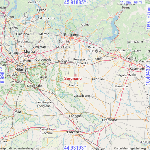
Sergnano GPS coordinates[2]
45° 25' 39.18" North, 9° 42' 4.392" East
| Map corner | latitude | longitude |
|---|---|---|
| Upper-left | 45.91885°, | 8.9981° |
| Center: | 45.42755°, | 9.70122° |
| Lower-right: | 44.93193°, | 10.40435° |
| Map W x H: | 109.7×109.7 km | = 68.2×68.2mi |
| max Lat: | 47.04031° ⇑28.8% North |
| Sergnano: | 45.42755° |
| min Lat: | ⇓71.2% South 35.50142° |
| min Long | Sergnano | max Long |
| 6.69888° | 9.70122° | 18.48682° |
| W 29.3%⇐ | ⇒70.7% E |
Elevation
Elevation of Sergnano is 89 m = 292 ft, and this is 217.7 m = 714 ft below average elevation for this country.
| Max E: |
2085 m = 6841 ft | 71.6% |
| Avg. | 306.7 m = 1006 ft | |
| Sergnano | 89 m = 292 ft | |
Min E: |
-4 m = -13 ft | 28.4% |
See also: Italy elevation on elevation.city.
Geographical zone
Sergnano is located in North temperate zone (between Tropic of Cancer and the Arctic Circle). Distance of this North polar circle is 2350.1 km =1460.3 mi to North.| Distance of | km | miles | from Sergnano |
|---|---|---|---|
| North Pole | 4956 | 3079.5 | to North |
| Arctic Circle | 2350.1 | 1460.3 | to North |
| Tropic Cancer | 2445.2 | 1519.4 | to South |
| Equator | 5051.1 | 3138.6 | to South |


Nearby cities:
15 places around Sergnano: (largest is in red/bold)
• Bottaiano
3.4 km =2.1 mi,  112°
112°
• Camisano
3.9 km =2.4 mi,  60°
60°
• Campagnola Cremasca
4.1 km =2.5 mi,  217°
217°
• Capralba
4.8 km =3 mi,  291°
291°
• Casale Cremasco
1.1 km =0.7 mi, 64°
• Casaletto Vaprio
6.1 km =3.8 mi,  249°
249°
• Casaletto di Sopra
6.4 km =4 mi,  98°
98°
• Castel Gabbiano
4.7 km =2.9 mi,  15°
15°
• Cremosano
6.1 km =3.8 mi,  233°
233°
• Mozzanica
5.6 km =3.5 mi,  349°
349°
• Offanengo
6.3 km =3.9 mi,  149°
149°
• Pianengo
2.9 km =1.8 mi,  190°
190°
• Quintano
6.5 km =4 mi,  263°
263°
• Ricengo
3 km =1.9 mi,  143°
143°
• Santo Stefano in Vairano
5.8 km =3.6 mi,  199°
199°
Sources, notices
• [Note1] Compared only with cities in Italy existing in our database
• [Src1] Map data: © OpenStreetMap contributors (CC-BY-SA)
• [Src2] Other city data from geonames.org with taken over terms of usage.
• [Src3] Geographical zone / Annual Mean Temperature by Robert A. Rohde @ Wikipedia
