Bottaiano geodata
Bottaiano (Lombardy) is a populated place; located in Italy in Europe/Rome (GMT+2) time zone. With population of 559 people, there are 9357 cities with bigger population in this country. Compared to other cities in Italy, 70.7% of cities are located further ↓South; 70.4% of cities are located further →East and 72.2% of cities have higher elevation than Bottaiano. Note1


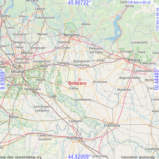
Bottaiano GPS coordinates[2]
45° 24' 56.916" North, 9° 44' 30.192" East
| Map corner | latitude | longitude |
|---|---|---|
| Upper-left | 45.90722°, | 9.03859° |
| Center: | 45.41581°, | 9.74172° |
| Lower-right: | 44.92009°, | 10.44485° |
| Map W x H: | 109.8×109.8 km | = 68.2×68.2mi |
| max Lat: | 47.04031° ⇑29.3% North |
| Bottaiano: | 45.41581° |
| min Lat: | ⇓70.7% South 35.50142° |
| min Long | Bottaiano | max Long |
| 6.69888° | 9.74172° | 18.48682° |
| W 29.6%⇐ | ⇒70.4% E |
Elevation
Elevation of Bottaiano is 87 m = 285 ft, and this is 219.7 m = 721 ft below average elevation for this country.
| Max E: |
2085 m = 6841 ft | 72.2% |
| Avg. | 306.7 m = 1006 ft | |
| Bottaiano | 87 m = 285 ft | |
Min E: |
-4 m = -13 ft | 27.8% |
See also: Italy elevation on elevation.city.
Geographical zone
Bottaiano is located in North temperate zone (between Tropic of Cancer and the Arctic Circle). Distance of this North polar circle is 2351.4 km =1461.1 mi to North.| Distance of | km | miles | from Bottaiano |
|---|---|---|---|
| North Pole | 4957.3 | 3080.3 | to North |
| Arctic Circle | 2351.4 | 1461.1 | to North |
| Tropic Cancer | 2443.8 | 1518.5 | to South |
| Equator | 5049.8 | 3137.8 | to South |


Nearby cities:
15 places around Bottaiano: (largest is in red/bold)
• Barbata
7.1 km =4.4 mi,  22°
22°
• Camisano
3.2 km =2 mi,  4°
4°
• Campagnola Cremasca
6 km =3.7 mi,  251°
251°
• Casale Cremasco
2.8 km =1.7 mi,  309°
309°
• Casaletto di Sopra
3.2 km =2 mi,  83°
83°
• Castel Gabbiano
6.1 km =3.8 mi,  342°
342°
• Isso
6.9 km =4.3 mi,  11°
11°
• Izano
6.7 km =4.2 mi,  173°
173°
• Offanengo
4.1 km =2.5 mi,  179°
179°
• Pianengo
4 km =2.5 mi, 247°
• Ricengo
1.8 km =1.1 mi,  230°
230°
• Romanengo
5.5 km =3.4 mi,  139°
139°
• Salvirola
7.2 km =4.5 mi,  156°
156°
• Santo Stefano in Vairano
6.6 km =4.1 mi, 230°
• Sergnano
3.4 km =2.1 mi,  292°
292°
Sources, notices
• [Note1] Compared only with cities in Italy existing in our database
• [Src1] Map data: © OpenStreetMap contributors (CC-BY-SA)
• [Src2] Other city data from geonames.org with taken over terms of usage.
• [Src3] Geographical zone / Annual Mean Temperature by Robert A. Rohde @ Wikipedia
