Santarcangelo geodata
Santarcangelo (Emilia-Romagna) is a seat of a third-order administrative division; located in Italy in Europe/Rome (GMT+2) time zone. With population of 10,934 people, there are 866 cities with bigger population in this country. Compared to other cities in Italy, 54.1% of cities are located further ↑North; 61.8% of cities are located further ←West and 82% of cities have higher elevation than Santarcangelo. Note1
Administrative division(s):
- Level 1: Emilia-Romagna
- Level 2: Provincia di Rimini
- Level 3: Santarcangelo di Romagna


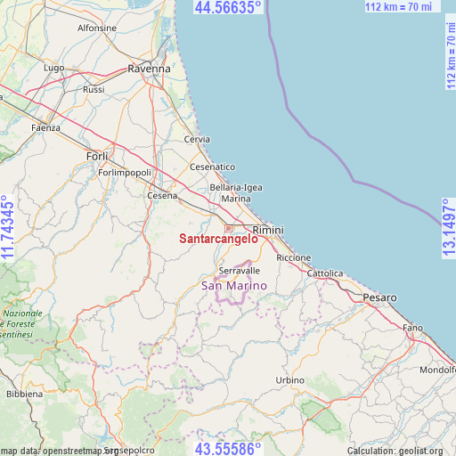
Santarcangelo GPS coordinates[2]
44° 3' 47.736" North, 12° 26' 47.652" East
| Map corner | latitude | longitude |
|---|---|---|
| Upper-left | 44.56635°, | 11.74345° |
| Center: | 44.06326°, | 12.44657° |
| Lower-right: | 43.55586°, | 13.1497° |
| Map W x H: | 112.4×112.4 km | = 69.8×69.8mi |
| max Lat: | 47.04031° ⇑54.1% North |
| Santarcangelo: | 44.06326° |
| min Lat: | ⇓45.9% South 35.50142° |
| min Long | Santarcangelo | max Long |
| 6.69888° | 12.44657° | 18.48682° |
| W 61.8%⇐ | ⇒38.2% E |
Elevation
Elevation of Santarcangelo is 42 m = 138 ft, and this is 264.7 m = 868 ft below average elevation for this country.
| Max E: |
2085 m = 6841 ft | 82% |
| Avg. | 306.7 m = 1006 ft | |
| Santarcangelo | 42 m = 138 ft | |
Min E: |
-4 m = -13 ft | 18% |
See also: Italy elevation on elevation.city.
Geographical zone
Santarcangelo is located in North temperate zone (between Tropic of Cancer and the Arctic Circle). Distance of this Northern Tropic circle is 2293.5 km =1425.1 mi to South.| Distance of | km | miles | from Santarcangelo |
|---|---|---|---|
| North Pole | 5107.7 | 3173.8 | to North |
| Arctic Circle | 2501.8 | 1554.5 | to North |
| Tropic Cancer | 2293.5 | 1425.1 | to South |
| Equator | 4899.4 | 3044.3 | to South |


Nearby cities:
15 places around Santarcangelo: (largest is in red/bold)
• Bellaria-Igea Marina
9 km =5.6 mi,  12°
12°
• Borghi
8 km =5 mi,  244°
244°
• Corpolò
4.9 km =3 mi,  174°
174°
• Gatteo-Sant'Angelo
7 km =4.3 mi,  320°
320°
• Longiano
9.4 km =5.8 mi,  277°
277°
• Poggio Berni
5.1 km =3.2 mi,  215°
215°
• San Martino dei Mulini
3.8 km =2.4 mi,  158°
158°
• San Mauro Pascoli
5.5 km =3.4 mi,  336°
336°
• San Michele
3 km =1.9 mi,  210°
210°
• Sant'Andrea
4 km =2.5 mi, 213°
• Santa Giustina
3.1 km =1.9 mi,  80°
80°
• Santo Marino
6.3 km =3.9 mi, 210°
• Savignano sul Rubicone
4.8 km =3 mi,  308°
308°
• Verucchio
9.3 km =5.8 mi,  191°
191°
• Villa Verucchio
6.5 km =4 mi, 187°
Sources, notices
• [Note1] Compared only with cities in Italy existing in our database
• [Src1] Map data: © OpenStreetMap contributors (CC-BY-SA)
• [Src2] Other city data from geonames.org with taken over terms of usage.
• [Src3] Geographical zone / Annual Mean Temperature by Robert A. Rohde @ Wikipedia
