Borghi geodata
Borghi (Emilia-Romagna) is a seat of a third-order administrative division; located in Italy in Europe/Rome (GMT+2) time zone. With population of 433 people, there are 10151 cities with bigger population in this country. Compared to other cities in Italy, 54.4% of cities are located further ↑North; 60.7% of cities are located further ←West and 52.5% of cities have lower elevation than Borghi. Note1
Administrative division(s):
- Level 1: Emilia-Romagna
- Level 2: Provincia di Forlì-Cesena
- Level 3: Borghi


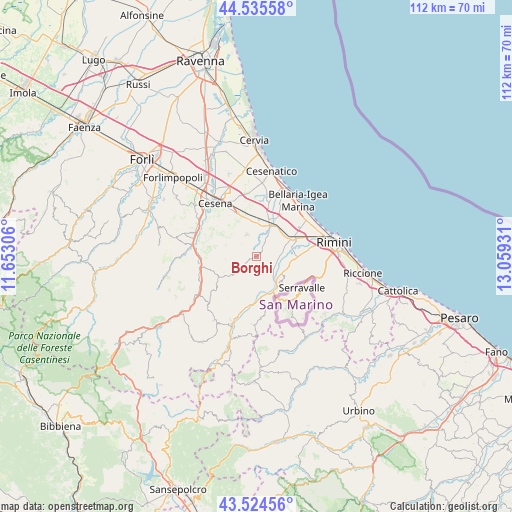
Borghi GPS coordinates[2]
44° 1' 56.028" North, 12° 21' 22.248" East
| Map corner | latitude | longitude |
|---|---|---|
| Upper-left | 44.53558°, | 11.65306° |
| Center: | 44.03223°, | 12.35618° |
| Lower-right: | 43.52456°, | 13.05931° |
| Map W x H: | 112.4×112.4 km | = 69.8×69.8mi |
| max Lat: | 47.04031° ⇑54.4% North |
| Borghi: | 44.03223° |
| min Lat: | ⇓45.6% South 35.50142° |
| min Long | Borghi | max Long |
| 6.69888° | 12.35618° | 18.48682° |
| W 60.7%⇐ | ⇒39.3% E |
Elevation
Elevation of Borghi is 250 m = 820 ft, and this is 56.7 m = 186 ft below average elevation for this country.
| Max E: |
2085 m = 6841 ft | 47.5% |
| Avg. | 306.7 m = 1006 ft | |
| Borghi | 250 m = 820 ft | |
Min E: |
-4 m = -13 ft | 52.5% |
See also: Italy elevation on elevation.city.
Geographical zone
Borghi is located in North temperate zone (between Tropic of Cancer and the Arctic Circle). Distance of this Northern Tropic circle is 2290 km =1422.9 mi to South.| Distance of | km | miles | from Borghi |
|---|---|---|---|
| North Pole | 5111.1 | 3175.9 | to North |
| Arctic Circle | 2505.2 | 1556.7 | to North |
| Tropic Cancer | 2290 | 1422.9 | to South |
| Equator | 4895.9 | 3042.2 | to South |


Nearby cities:
15 places around Borghi: (largest is in red/bold)
• Budrio
7.5 km =4.7 mi,  350°
350°
• Corpolò
7.9 km =4.9 mi,  100°
100°
• Longiano
5.2 km =3.2 mi,  335°
335°
• Montiano
6.9 km =4.3 mi,  323°
323°
• Poggio Berni
4.3 km =2.7 mi, 98°
• Roncofreddo
4.6 km =2.9 mi,  284°
284°
• Roncofreddo-Santa Paola
3.5 km =2.2 mi,  289°
289°
• San Michele
5.8 km =3.6 mi,  81°
81°
• Sant'Andrea
5 km =3.1 mi,  88°
88°
• Santo Marino
4.5 km =2.8 mi,  116°
116°
• Savignano sul Rubicone
7.3 km =4.5 mi,  28°
28°
• Sogliano al Rubicone
5.3 km =3.3 mi,  235°
235°
• Torriana
5.8 km =3.6 mi,  156°
156°
• Verucchio
7.8 km =4.8 mi,  136°
136°
• Villa Verucchio
7 km =4.3 mi, 115°
Sources, notices
• [Note1] Compared only with cities in Italy existing in our database
• [Src1] Map data: © OpenStreetMap contributors (CC-BY-SA)
• [Src2] Other city data from geonames.org with taken over terms of usage.
• [Src3] Geographical zone / Annual Mean Temperature by Robert A. Rohde @ Wikipedia
