Santa Maria Maggiore geodata
Santa Maria Maggiore (Piedmont) is a seat of a third-order administrative division; located in Italy in Europe/Rome (GMT+1) time zone. With population of 1,264 people, there are 5743 cities with bigger population in this country. Compared to other cities in Italy, 94.7% of cities are located further ↓South; 88.4% of cities are located further →East and 93.8% of cities have lower elevation than Santa Maria Maggiore. Note1
Administrative division(s):
- Level 1: Piedmont
- Level 2: Provincia Verbano-Cusio-Ossola
- Level 3: Santa Maria Maggiore


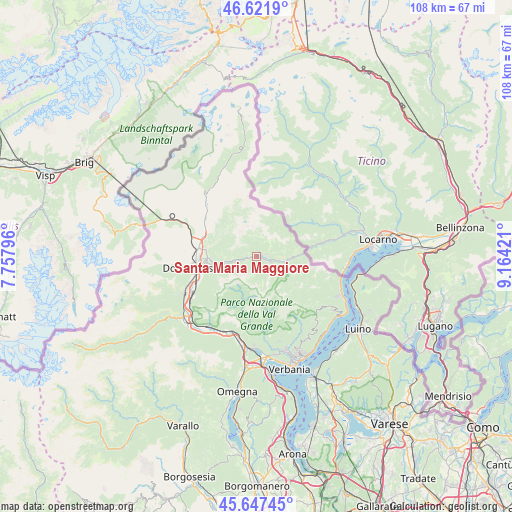
Santa Maria Maggiore GPS coordinates[2]
46° 8' 12.588" North, 8° 27' 39.888" East
| Map corner | latitude | longitude |
|---|---|---|
| Upper-left | 46.6219°, | 7.75796° |
| Center: | 46.13683°, | 8.46108° |
| Lower-right: | 45.64745°, | 9.16421° |
| Map W x H: | 108.3×108.3 km | = 67.3×67.3mi |
| max Lat: | 47.04031° ⇑5.3% North |
| Santa Maria Maggiore: | 46.13683° |
| min Lat: | ⇓94.7% South 35.50142° |
| min Long | Santa Maria Mag | max Long |
| 6.69888° | 8.46108° | 18.48682° |
| W 11.6%⇐ | ⇒88.4% E |
Elevation
Elevation of Santa Maria Maggiore is 832 m = 2730 ft, and this is 525.3 m = 1723 ft above average elevation for this country.
| Max E: |
2085 m = 6841 ft | 6.2% |
| Santa Maria Maggiore | 832 m 2730 ft | |
| Avg. | 306.7 m = 1006 ft | |
Min E: |
-4 m = -13 ft | 93.8% |
See also: Italy elevation on elevation.city.
Geographical zone
Santa Maria Maggiore is located in North temperate zone (between Tropic of Cancer and the Arctic Circle). Distance of this North polar circle is 2271.2 km =1411.3 mi to North.| Distance of | km | miles | from Santa Maria Maggiore |
|---|---|---|---|
| North Pole | 4877.1 | 3030.5 | to North |
| Arctic Circle | 2271.2 | 1411.3 | to North |
| Tropic Cancer | 2524 | 1568.3 | to South |
| Equator | 5129.9 | 3187.6 | to South |


Nearby cities:
15 places around Santa Maria Maggiore: (largest is in red/bold)
• Craveggia
2.2 km =1.4 mi,  77°
77°
• Crevoladossola
12.7 km =7.9 mi,  275°
275°
• Croppo
12.4 km =7.7 mi,  252°
252°
• Cursolo
9.3 km =5.8 mi,  117°
117°
• Druogno
2.2 km =1.4 mi,  262°
262°
• Falmenta
12.2 km =7.6 mi,  125°
125°
• Gurro
10 km =6.2 mi, 125°
• Malesco
3 km =1.9 mi,  109°
109°
• Masera
10.5 km =6.5 mi,  271°
271°
• Montecrestese
10.8 km =6.7 mi,  286°
286°
• Pontetto-Roldo
10.9 km =6.8 mi, 278°
• Re
6.5 km =4 mi,  95°
95°
• Toceno
1.1 km =0.7 mi,  35°
35°
• Trontano
10 km =6.2 mi, 260°
• Villette
5.7 km =3.5 mi, 95°
Sources, notices
• [Note1] Compared only with cities in Italy existing in our database
• [Src1] Map data: © OpenStreetMap contributors (CC-BY-SA)
• [Src2] Other city data from geonames.org with taken over terms of usage.
• [Src3] Geographical zone / Annual Mean Temperature by Robert A. Rohde @ Wikipedia
