Rovereto geodata
Rovereto (Emilia-Romagna) is a populated place; located in Italy in Europe/Rome (GMT+2) time zone. With population of 3,316 people, there are 2825 cities with bigger population in this country. Compared to other cities in Italy, 56.8% of cities are located further ↓South; 57.9% of cities are located further →East and 89.6% of cities have higher elevation than Rovereto. Note1
Administrative division(s):
- Level 1: Emilia-Romagna
- Level 2: Provincia di Modena
- Level 3: Novi di Modena


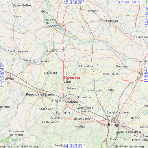
Rovereto GPS coordinates[2]
44° 50' 1.716" North, 10° 57' 5.652" East
| Map corner | latitude | longitude |
|---|---|---|
| Upper-left | 45.33028°, | 10.24845° |
| Center: | 44.83381°, | 10.95157° |
| Lower-right: | 44.33303°, | 11.6547° |
| Map W x H: | 110.9×110.9 km | = 68.9×68.9mi |
| max Lat: | 47.04031° ⇑43.2% North |
| Rovereto: | 44.83381° |
| min Lat: | ⇓56.8% South 35.50142° |
| min Long | Rovereto | max Long |
| 6.69888° | 10.95157° | 18.48682° |
| W 42.1%⇐ | ⇒57.9% E |
Elevation
Elevation of Rovereto is 19 m = 62 ft, and this is 287.7 m = 944 ft below average elevation for this country.
| Max E: |
2085 m = 6841 ft | 89.6% |
| Avg. | 306.7 m = 1006 ft | |
| Rovereto | 19 m = 62 ft | |
Min E: |
-4 m = -13 ft | 10.4% |
See also: Italy elevation on elevation.city.
Geographical zone
Rovereto is located in North temperate zone (between Tropic of Cancer and the Arctic Circle). Distance of this Northern Tropic circle is 2379.1 km =1478.3 mi to South.| Distance of | km | miles | from Rovereto |
|---|---|---|---|
| North Pole | 5022 | 3120.5 | to North |
| Arctic Circle | 2416.1 | 1501.3 | to North |
| Tropic Cancer | 2379.1 | 1478.3 | to South |
| Equator | 4985.1 | 3097.6 | to South |


Nearby cities:
15 places around Rovereto: (largest is in red/bold)
• Budrione
7.6 km =4.7 mi,  254°
254°
• Carpi Centro
8.2 km =5.1 mi,  225°
225°
• Cavezzo
6.1 km =3.8 mi,  88°
88°
• Concordia sulla Secchia
9.2 km =5.7 mi,  18°
18°
• Fossoli
5.1 km =3.2 mi, 254°
• Limidi
8.1 km =5 mi,  197°
197°
• Medolla
9.3 km =5.8 mi,  81°
81°
• Migliarina
9.5 km =5.9 mi, 254°
• Novi di Modena
7.4 km =4.6 mi,  326°
326°
• Rolo
9.2 km =5.7 mi,  308°
308°
• Sam Marino
4.2 km =2.6 mi,  224°
224°
• San Possidonio
5 km =3.1 mi,  27°
27°
• San Prospero
7.4 km =4.6 mi,  131°
131°
• Sozzigalli
9.6 km =6 mi,  169°
169°
• Villa Motta
3.7 km =2.3 mi,  104°
104°
Sources, notices
• [Note1] Compared only with cities in Italy existing in our database
• [Src1] Map data: © OpenStreetMap contributors (CC-BY-SA)
• [Src2] Other city data from geonames.org with taken over terms of usage.
• [Src3] Geographical zone / Annual Mean Temperature by Robert A. Rohde @ Wikipedia
