Cavezzo geodata
Cavezzo (Emilia-Romagna) is a seat of a third-order administrative division; located in Italy in Europe/Rome (GMT+2) time zone. With population of 5,464 people, there are 1796 cities with bigger population in this country. Compared to other cities in Italy, 56.8% of cities are located further ↓South; 56.9% of cities are located further →East and 87.8% of cities have higher elevation than Cavezzo. Note1


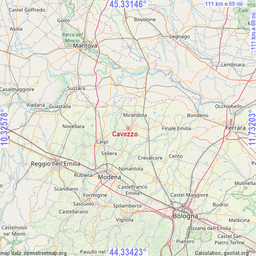
Cavezzo GPS coordinates[2]
44° 50' 6" North, 11° 1' 44.04" East
| Map corner | latitude | longitude |
|---|---|---|
| Upper-left | 45.33146°, | 10.32578° |
| Center: | 44.835°, | 11.0289° |
| Lower-right: | 44.33423°, | 11.73203° |
| Map W x H: | 110.9×110.9 km | = 68.9×68.9mi |
| max Lat: | 47.04031° ⇑43.2% North |
| Cavezzo: | 44.835° |
| min Lat: | ⇓56.8% South 35.50142° |
| min Long | Cavezzo | max Long |
| 6.69888° | 11.0289° | 18.48682° |
| W 43.1%⇐ | ⇒56.9% E |
Elevation
Elevation of Cavezzo is 23 m = 75 ft, and this is 283.7 m = 931 ft below average elevation for this country.
| Max E: |
2085 m = 6841 ft | 87.8% |
| Avg. | 306.7 m = 1006 ft | |
| Cavezzo | 23 m = 75 ft | |
Min E: |
-4 m = -13 ft | 12.2% |
See also: Italy elevation on elevation.city.
Geographical zone
Cavezzo is located in North temperate zone (between Tropic of Cancer and the Arctic Circle). Distance of this Northern Tropic circle is 2379.3 km =1478.4 mi to South.| Distance of | km | miles | from Cavezzo |
|---|---|---|---|
| North Pole | 5021.9 | 3120.5 | to North |
| Arctic Circle | 2416 | 1501.2 | to North |
| Tropic Cancer | 2379.3 | 1478.4 | to South |
| Equator | 4985.2 | 3097.7 | to South |


Nearby cities:
15 places around Cavezzo: (largest is in red/bold)
• Concordia sulla Secchia
9.2 km =5.7 mi,  339°
339°
• Fossa
9.8 km =6.1 mi,  357°
357°
• Gorghetto
7.9 km =4.9 mi,  154°
154°
• Medolla
3.3 km =2.1 mi,  66°
66°
• Mirandola
6.4 km =4 mi,  29°
29°
• Rovereto
6.1 km =3.8 mi,  268°
268°
• Sam Marino
9.5 km =5.9 mi,  251°
251°
• San Biagio
7.9 km =4.9 mi, 68°
• San Felice sul Panaro
8.6 km =5.3 mi,  88°
88°
• San Pietro
7 km =4.3 mi,  169°
169°
• San Possidonio
5.8 km =3.6 mi,  318°
318°
• San Prospero
5.1 km =3.2 mi,  186°
186°
• Solara
8.7 km =5.4 mi,  144°
144°
• Sorbara
9.8 km =6.1 mi, 189°
• Villa Motta
2.7 km =1.7 mi, 246°
Sources, notices
• [Note1] Compared only with cities in Italy existing in our database
• [Src1] Map data: © OpenStreetMap contributors (CC-BY-SA)
• [Src2] Other city data from geonames.org with taken over terms of usage.
• [Src3] Geographical zone / Annual Mean Temperature by Robert A. Rohde @ Wikipedia
