Robbiate geodata
Robbiate (Lombardy) is a seat of a third-order administrative division; located in Italy in Europe/Rome (GMT+2) time zone. With population of 5,969 people, there are 1643 cities with bigger population in this country. Compared to other cities in Italy, 80.6% of cities are located further ↓South; 74.1% of cities are located further →East and 55.4% of cities have lower elevation than Robbiate. Note1


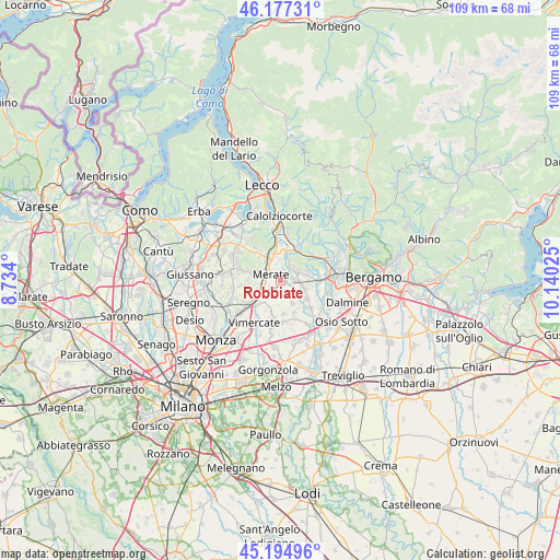
Robbiate GPS coordinates[2]
45° 41' 17.844" North, 9° 26' 13.632" East
| Map corner | latitude | longitude |
|---|---|---|
| Upper-left | 46.17731°, | 8.734° |
| Center: | 45.68829°, | 9.43712° |
| Lower-right: | 45.19496°, | 10.14025° |
| Map W x H: | 109.2×109.2 km | = 67.9×67.9mi |
| max Lat: | 47.04031° ⇑19.4% North |
| Robbiate: | 45.68829° |
| min Lat: | ⇓80.6% South 35.50142° |
| min Long | Robbiate | max Long |
| 6.69888° | 9.43712° | 18.48682° |
| W 25.9%⇐ | ⇒74.1% E |
Elevation
Elevation of Robbiate is 268 m = 879 ft, and this is 38.7 m = 127 ft below average elevation for this country.
| Max E: |
2085 m = 6841 ft | 44.6% |
| Avg. | 306.7 m = 1006 ft | |
| Robbiate | 268 m = 879 ft | |
Min E: |
-4 m = -13 ft | 55.4% |
See also: Italy elevation on elevation.city.
Geographical zone
Robbiate is located in North temperate zone (between Tropic of Cancer and the Arctic Circle). Distance of this North polar circle is 2321.1 km =1442.3 mi to North.| Distance of | km | miles | from Robbiate |
|---|---|---|---|
| North Pole | 4927 | 3061.5 | to North |
| Arctic Circle | 2321.1 | 1442.3 | to North |
| Tropic Cancer | 2474.1 | 1537.3 | to South |
| Equator | 5080.1 | 3156.6 | to South |


Nearby cities:
15 places around Robbiate: (largest is in red/bold)
• Arlate
4 km =2.5 mi,  5°
5°
• Calusco d'Adda
2.6 km =1.6 mi,  89°
89°
• Carvico
4.1 km =2.5 mi,  68°
68°
• Cassina Fra Martino
3.3 km =2.1 mi,  354°
354°
• Cernusco Lombardone
3 km =1.9 mi,  275°
275°
• Imbersago
2 km =1.2 mi,  16°
16°
• Merate
1.3 km =0.8 mi,  271°
271°
• Osnago
3.8 km =2.4 mi,  247°
247°
• Paderno d'Adda
1.2 km =0.7 mi,  150°
150°
• Porto d'Adda
4.2 km =2.6 mi,  133°
133°
• Ronco Briantino
3.5 km =2.2 mi,  225°
225°
• Solza
4.3 km =2.7 mi,  104°
104°
• Verderio Inferiore
2.5 km =1.6 mi,  186°
186°
• Verderio Superiore
2.3 km =1.4 mi,  173°
173°
• Villa d'Adda
3.4 km =2.1 mi,  33°
33°
Sources, notices
• [Note1] Compared only with cities in Italy existing in our database
• [Src1] Map data: © OpenStreetMap contributors (CC-BY-SA)
• [Src2] Other city data from geonames.org with taken over terms of usage.
• [Src3] Geographical zone / Annual Mean Temperature by Robert A. Rohde @ Wikipedia
