Carvico geodata
Carvico (Lombardy) is a seat of a third-order administrative division; located in Italy in Europe/Rome (GMT+2) time zone. With population of 4,618 people, there are 2101 cities with bigger population in this country. Compared to other cities in Italy, 81.2% of cities are located further ↓South; 73.4% of cities are located further →East and 56.6% of cities have lower elevation than Carvico. Note1


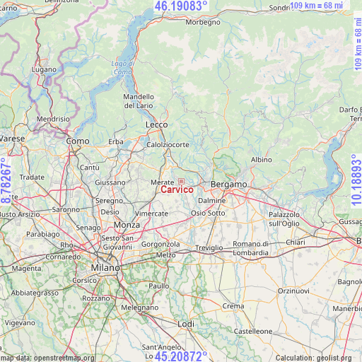
Carvico GPS coordinates[2]
45° 42' 6.948" North, 9° 29' 8.88" East
| Map corner | latitude | longitude |
|---|---|---|
| Upper-left | 46.19083°, | 8.78267° |
| Center: | 45.70193°, | 9.4858° |
| Lower-right: | 45.20872°, | 10.18893° |
| Map W x H: | 109.2×109.2 km | = 67.9×67.9mi |
| max Lat: | 47.04031° ⇑18.8% North |
| Carvico: | 45.70193° |
| min Lat: | ⇓81.2% South 35.50142° |
| min Long | Carvico | max Long |
| 6.69888° | 9.4858° | 18.48682° |
| W 26.6%⇐ | ⇒73.4% E |
Elevation
Elevation of Carvico is 276 m = 906 ft, and this is 30.7 m = 101 ft below average elevation for this country.
| Max E: |
2085 m = 6841 ft | 43.4% |
| Avg. | 306.7 m = 1006 ft | |
| Carvico | 276 m = 906 ft | |
Min E: |
-4 m = -13 ft | 56.6% |
See also: Italy elevation on elevation.city.
Geographical zone
Carvico is located in North temperate zone (between Tropic of Cancer and the Arctic Circle). Distance of this North polar circle is 2319.6 km =1441.3 mi to North.| Distance of | km | miles | from Carvico |
|---|---|---|---|
| North Pole | 4925.5 | 3060.6 | to North |
| Arctic Circle | 2319.6 | 1441.3 | to North |
| Tropic Cancer | 2475.7 | 1538.3 | to South |
| Equator | 5081.6 | 3157.6 | to South |


Nearby cities:
15 places around Carvico: (largest is in red/bold)
• Arlate
4.1 km =2.5 mi,  305°
305°
• Calusco d'Adda
1.9 km =1.2 mi,  217°
217°
• Imbersago
3.2 km =2 mi,  277°
277°
• Medolago
3.5 km =2.2 mi,  164°
164°
• Paderno d'Adda
4.1 km =2.5 mi,  230°
230°
• Piazza Caduti
1.3 km =0.8 mi,  74°
74°
• Pontida
3.8 km =2.4 mi,  31°
31°
• Porto d'Adda
4.5 km =2.8 mi,  190°
190°
• Pratolongo
2.3 km =1.4 mi, 69°
• Robbiate
4.1 km =2.5 mi,  248°
248°
• Solza
2.6 km =1.6 mi,  171°
171°
• Sotto il Monte Giovanni XXIII
1.4 km =0.9 mi, 73°
• Terno d'Isola
4 km =2.5 mi,  117°
117°
• Valtrighe
4 km =2.5 mi,  99°
99°
• Villa d'Adda
2.3 km =1.4 mi, 305°
Sources, notices
• [Note1] Compared only with cities in Italy existing in our database
• [Src1] Map data: © OpenStreetMap contributors (CC-BY-SA)
• [Src2] Other city data from geonames.org with taken over terms of usage.
• [Src3] Geographical zone / Annual Mean Temperature by Robert A. Rohde @ Wikipedia
