Ripafratta-Farneta geodata
Ripafratta-Farneta (Tuscany) is a populated place; located in Italy in Europe/Rome (GMT+2) time zone. With population of 668 people, there are 8500 cities with bigger population in this country. Compared to other cities in Italy, 56.8% of cities are located further ↑North; 63.7% of cities are located further →East and 84.1% of cities have higher elevation than Ripafratta-Farneta. Note1


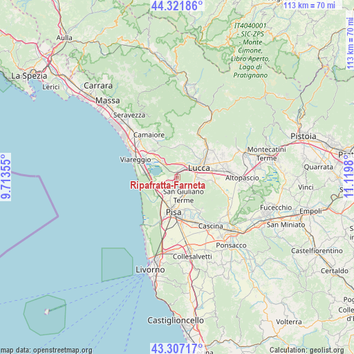
Ripafratta-Farneta GPS coordinates[2]
43° 49' 0.012" North, 10° 25' 0.012" East
| Map corner | latitude | longitude |
|---|---|---|
| Upper-left | 44.32186°, | 9.71355° |
| Center: | 43.81667°, | 10.41667° |
| Lower-right: | 43.30717°, | 11.1198° |
| Map W x H: | 112.8×112.8 km | = 70.1×70.1mi |
| max Lat: | 47.04031° ⇑56.8% North |
| Ripafratta-Farneta: | 43.81667° |
| min Lat: | ⇓43.2% South 35.50142° |
| min Long | Ripafratta-Farn | max Long |
| 6.69888° | 10.41667° | 18.48682° |
| W 36.3%⇐ | ⇒63.7% E |
Elevation
Elevation of Ripafratta-Farneta is 34 m = 112 ft, and this is 272.7 m = 895 ft below average elevation for this country.
| Max E: |
2085 m = 6841 ft | 84.1% |
| Avg. | 306.7 m = 1006 ft | |
| Ripafratta-Farneta | 34 m = 112 ft | |
Min E: |
-4 m = -13 ft | 15.9% |
See also: Italy elevation on elevation.city.
Geographical zone
Ripafratta-Farneta is located in North temperate zone (between Tropic of Cancer and the Arctic Circle). Distance of this Northern Tropic circle is 2266 km =1408 mi to South.| Distance of | km | miles | from Ripafratta-Farneta |
|---|---|---|---|
| North Pole | 5135.1 | 3190.8 | to North |
| Arctic Circle | 2529.2 | 1571.6 | to North |
| Tropic Cancer | 2266 | 1408 | to South |
| Equator | 4872 | 3027.3 | to South |


Nearby cities:
15 places around Ripafratta-Farneta: (largest is in red/bold)
• Asciano
8.2 km =5.1 mi,  151°
151°
• Avane
3 km =1.9 mi,  190°
190°
• Filettole
1.2 km =0.7 mi,  250°
250°
• Gello
7 km =4.3 mi,  175°
175°
• Lucca
7.7 km =4.8 mi,  66°
66°
• Madonna dell'Acqua
8.9 km =5.5 mi,  202°
202°
• Massarosa
8 km =5 mi,  313°
313°
• Metato
6 km =3.7 mi,  217°
217°
• Migliarino
8.4 km =5.2 mi,  227°
227°
• Orzignano
4.8 km =3 mi,  173°
173°
• Pontasserchio
4.1 km =2.5 mi, 179°
• Ponte d'Oro
7.5 km =4.7 mi,  214°
214°
• San Giuliano Terme
6.1 km =3.8 mi,  163°
163°
• Torre del Lago Puccini
10.3 km =6.4 mi,  277°
277°
• Vecchiano-Nodica
4.5 km =2.8 mi, 214°
Sources, notices
• [Note1] Compared only with cities in Italy existing in our database
• [Src1] Map data: © OpenStreetMap contributors (CC-BY-SA)
• [Src2] Other city data from geonames.org with taken over terms of usage.
• [Src3] Geographical zone / Annual Mean Temperature by Robert A. Rohde @ Wikipedia
