Filettole geodata
Filettole (Tuscany) is a populated place; located in Italy in Europe/Rome (GMT+2) time zone. With population of 1,382 people, there are 5402 cities with bigger population in this country. Compared to other cities in Italy, 56.8% of cities are located further ↑North; 63.9% of cities are located further →East and 94.8% of cities have higher elevation than Filettole. Note1


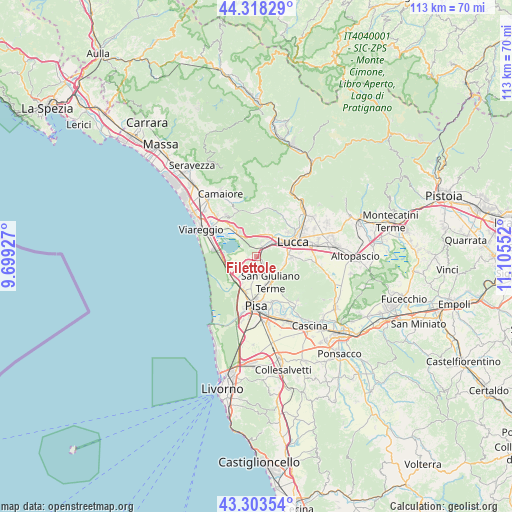
Filettole GPS coordinates[2]
43° 48' 47.052" North, 10° 24' 8.604" East
| Map corner | latitude | longitude |
|---|---|---|
| Upper-left | 44.31829°, | 9.69927° |
| Center: | 43.81307°, | 10.40239° |
| Lower-right: | 43.30354°, | 11.10552° |
| Map W x H: | 112.8×112.8 km | = 70.1×70.1mi |
| max Lat: | 47.04031° ⇑56.8% North |
| Filettole: | 43.81307° |
| min Lat: | ⇓43.2% South 35.50142° |
| min Long | Filettole | max Long |
| 6.69888° | 10.40239° | 18.48682° |
| W 36.1%⇐ | ⇒63.9% E |
Elevation
Elevation of Filettole is 9 m = 30 ft, and this is 297.7 m = 977 ft below average elevation for this country.
| Max E: |
2085 m = 6841 ft | 94.8% |
| Avg. | 306.7 m = 1006 ft | |
| Filettole | 9 m = 30 ft | |
Min E: |
-4 m = -13 ft | 5.2% |
See also: Italy elevation on elevation.city.
Geographical zone
Filettole is located in North temperate zone (between Tropic of Cancer and the Arctic Circle). Distance of this Northern Tropic circle is 2265.6 km =1407.8 mi to South.| Distance of | km | miles | from Filettole |
|---|---|---|---|
| North Pole | 5135.5 | 3191.1 | to North |
| Arctic Circle | 2529.6 | 1571.8 | to North |
| Tropic Cancer | 2265.6 | 1407.8 | to South |
| Equator | 4871.6 | 3027.1 | to South |


Nearby cities:
15 places around Filettole: (largest is in red/bold)
• Asciano
8.5 km =5.3 mi,  143°
143°
• Avane
2.6 km =1.6 mi,  166°
166°
• Gello
6.8 km =4.2 mi, 165°
• Lucca
8.9 km =5.5 mi,  67°
67°
• Madonna dell'Acqua
8.1 km =5 mi,  195°
195°
• Massarosa
7.5 km =4.7 mi,  321°
321°
• Metato
5.1 km =3.2 mi,  209°
209°
• Migliarino
7.3 km =4.5 mi,  223°
223°
• Orzignano
4.7 km =2.9 mi,  158°
158°
• Pontasserchio
3.9 km =2.4 mi, 162°
• Ponte d'Oro
6.6 km =4.1 mi, 208°
• Ripafratta-Farneta
1.2 km =0.7 mi, 70°
• San Giuliano Terme
6.2 km =3.9 mi,  152°
152°
• Torre del Lago Puccini
9.3 km =5.8 mi,  280°
280°
• Vecchiano-Nodica
3.6 km =2.2 mi, 203°
Sources, notices
• [Note1] Compared only with cities in Italy existing in our database
• [Src1] Map data: © OpenStreetMap contributors (CC-BY-SA)
• [Src2] Other city data from geonames.org with taken over terms of usage.
• [Src3] Geographical zone / Annual Mean Temperature by Robert A. Rohde @ Wikipedia
