Rignano sull'Arno geodata
Rignano sull'Arno (Tuscany) is a seat of a third-order administrative division; located in Italy in Europe/Rome (GMT+2) time zone. With population of 3,343 people, there are 2806 cities with bigger population in this country. Compared to other cities in Italy, 57.9% of cities are located further ↑North; 51.2% of cities are located further →East and 63.9% of cities have higher elevation than Rignano sull'Arno. Note1
Administrative division(s):
- Level 1: Tuscany
- Level 2: Province of Florence
- Level 3: Rignano sull'Arno


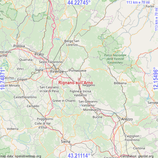
Rignano sull'Arno GPS coordinates[2]
43° 43' 17.22" North, 11° 27' 6.588" East
| Map corner | latitude | longitude |
|---|---|---|
| Upper-left | 44.22745°, | 10.74871° |
| Center: | 43.72145°, | 11.45183° |
| Lower-right: | 43.21114°, | 12.15496° |
| Map W x H: | 113×113 km | = 70.2×70.2mi |
| max Lat: | 47.04031° ⇑57.9% North |
| Rignano sull'Arno: | 43.72145° |
| min Lat: | ⇓42.1% South 35.50142° |
| min Long | Rignano sull'Ar | max Long |
| 6.69888° | 11.45183° | 18.48682° |
| W 48.8%⇐ | ⇒51.2% E |
Elevation
Elevation of Rignano sull'Arno is 135 m = 443 ft, and this is 171.7 m = 563 ft below average elevation for this country.
| Max E: |
2085 m = 6841 ft | 63.9% |
| Avg. | 306.7 m = 1006 ft | |
| Rignano sull'Arno | 135 m = 443 ft | |
Min E: |
-4 m = -13 ft | 36.1% |
See also: Italy elevation on elevation.city.
Geographical zone
Rignano sull'Arno is located in North temperate zone (between Tropic of Cancer and the Arctic Circle). Distance of this Northern Tropic circle is 2255.5 km =1401.5 mi to South.| Distance of | km | miles | from Rignano sull'Arno |
|---|---|---|---|
| North Pole | 5145.7 | 3197.4 | to North |
| Arctic Circle | 2539.8 | 1578.2 | to North |
| Tropic Cancer | 2255.5 | 1401.5 | to South |
| Equator | 4861.4 | 3020.7 | to South |


Nearby cities:
15 places around Rignano sull'Arno: (largest is in red/bold)
• Cancelli
6 km =3.7 mi,  127°
127°
• Ciliegi
6.2 km =3.9 mi,  174°
174°
• Diacceto
8.1 km =5 mi,  30°
30°
• Donnini
4.2 km =2.6 mi,  72°
72°
• Incisa in Val d'Arno
7.4 km =4.6 mi,  181°
181°
• Leccio
2.7 km =1.7 mi,  154°
154°
• Pelago
6.9 km =4.3 mi,  35°
35°
• Pietrapiana
6.9 km =4.3 mi,  113°
113°
• Pontassieve
6.2 km =3.9 mi,  344°
344°
• Reggello
7.8 km =4.8 mi, 126°
• Rosano
5.9 km =3.7 mi, 336°
• San Clemente
0.5 km =0.3 mi,  119°
119°
• San Francesco
5.9 km =3.7 mi,  357°
357°
• Tosi
7.1 km =4.4 mi,  64°
64°
• Troghi
4.6 km =2.9 mi,  260°
260°
Sources, notices
• [Note1] Compared only with cities in Italy existing in our database
• [Src1] Map data: © OpenStreetMap contributors (CC-BY-SA)
• [Src2] Other city data from geonames.org with taken over terms of usage.
• [Src3] Geographical zone / Annual Mean Temperature by Robert A. Rohde @ Wikipedia
