Pontassieve geodata
Pontassieve (Tuscany) is a seat of a third-order administrative division; located in Italy in Europe/Rome (GMT+2) time zone. With population of 9,890 people, there are 957 cities with bigger population in this country. Compared to other cities in Italy, 57.3% of cities are located further ↑North; 51.5% of cities are located further →East and 71.1% of cities have higher elevation than Pontassieve. Note1


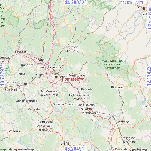
Pontassieve GPS coordinates[2]
43° 46' 29.172" North, 11° 25' 51.924" East
| Map corner | latitude | longitude |
|---|---|---|
| Upper-left | 44.28032°, | 10.72797° |
| Center: | 43.77477°, | 11.43109° |
| Lower-right: | 43.26491°, | 12.13422° |
| Map W x H: | 112.9×112.9 km | = 70.2×70.2mi |
| max Lat: | 47.04031° ⇑57.3% North |
| Pontassieve: | 43.77477° |
| min Lat: | ⇓42.7% South 35.50142° |
| min Long | Pontassieve | max Long |
| 6.69888° | 11.43109° | 18.48682° |
| W 48.5%⇐ | ⇒51.5% E |
Elevation
Elevation of Pontassieve is 92 m = 302 ft, and this is 214.7 m = 704 ft below average elevation for this country.
| Max E: |
2085 m = 6841 ft | 71.1% |
| Avg. | 306.7 m = 1006 ft | |
| Pontassieve | 92 m = 302 ft | |
Min E: |
-4 m = -13 ft | 28.9% |
See also: Italy elevation on elevation.city.
Geographical zone
Pontassieve is located in North temperate zone (between Tropic of Cancer and the Arctic Circle). Distance of this Northern Tropic circle is 2261.4 km =1405.2 mi to South.| Distance of | km | miles | from Pontassieve |
|---|---|---|---|
| North Pole | 5139.8 | 3193.7 | to North |
| Arctic Circle | 2533.9 | 1574.5 | to North |
| Tropic Cancer | 2261.4 | 1405.2 | to South |
| Equator | 4867.3 | 3024.4 | to South |


Nearby cities:
15 places around Pontassieve: (largest is in red/bold)
• Compiobbi
5.9 km =3.7 mi,  280°
280°
• Diacceto
5.9 km =3.7 mi,  79°
79°
• Donnini
7.4 km =4.6 mi,  129°
129°
• Molino del Piano
4.7 km =2.9 mi,  328°
328°
• Montebonello
7.6 km =4.7 mi,  35°
35°
• Pelago
5.7 km =3.5 mi,  92°
92°
• Rignano sull'Arno
6.2 km =3.9 mi,  164°
164°
• Rimaggio
8.2 km =5.1 mi,  256°
256°
• Rosano
0.8 km =0.5 mi,  229°
229°
• Rufina
7.1 km =4.4 mi, 39°
• San Clemente
6.5 km =4 mi, 161°
• San Francesco
1.4 km =0.9 mi, 89°
• San Jacopo al Girone
7.3 km =4.5 mi,  265°
265°
• Sieci
3.3 km =2.1 mi,  297°
297°
• Troghi
7.3 km =4.5 mi,  203°
203°
Sources, notices
• [Note1] Compared only with cities in Italy existing in our database
• [Src1] Map data: © OpenStreetMap contributors (CC-BY-SA)
• [Src2] Other city data from geonames.org with taken over terms of usage.
• [Src3] Geographical zone / Annual Mean Temperature by Robert A. Rohde @ Wikipedia
