Quercianella geodata
Quercianella (Tuscany) is a populated place; located in Italy in Europe/Rome (GMT+2) time zone. With population of 1,039 people, there are 6510 cities with bigger population in this country. Compared to other cities in Italy, 60.2% of cities are located further ↑North; 64.3% of cities are located further →East and 89% of cities have higher elevation than Quercianella. Note1


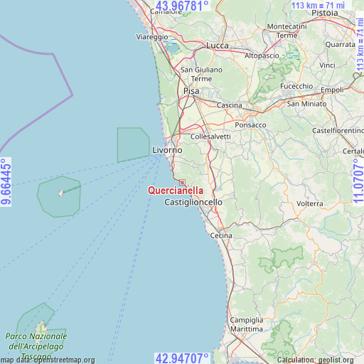
Quercianella GPS coordinates[2]
43° 27' 34.524" North, 10° 22' 3.252" East
| Map corner | latitude | longitude |
|---|---|---|
| Upper-left | 43.96781°, | 9.66445° |
| Center: | 43.45959°, | 10.36757° |
| Lower-right: | 42.94707°, | 11.0707° |
| Map W x H: | 113.5×113.5 km | = 70.5×70.5mi |
| max Lat: | 47.04031° ⇑60.2% North |
| Quercianella: | 43.45959° |
| min Lat: | ⇓39.8% South 35.50142° |
| min Long | Quercianella | max Long |
| 6.69888° | 10.36757° | 18.48682° |
| W 35.7%⇐ | ⇒64.3% E |
Elevation
Elevation of Quercianella is 20 m = 66 ft, and this is 286.7 m = 941 ft below average elevation for this country.
| Max E: |
2085 m = 6841 ft | 89% |
| Avg. | 306.7 m = 1006 ft | |
| Quercianella | 20 m = 66 ft | |
Min E: |
-4 m = -13 ft | 11% |
See also: Italy elevation on elevation.city.
Geographical zone
Quercianella is located in North temperate zone (between Tropic of Cancer and the Arctic Circle). Distance of this Northern Tropic circle is 2226.3 km =1383.4 mi to South.| Distance of | km | miles | from Quercianella |
|---|---|---|---|
| North Pole | 5174.8 | 3215.5 | to North |
| Arctic Circle | 2568.9 | 1596.2 | to North |
| Tropic Cancer | 2226.3 | 1383.4 | to South |
| Equator | 4832.3 | 3002.7 | to South |


Nearby cities:
15 places around Quercianella: (largest is in red/bold)
• Castellina Marittima
17.6 km =10.9 mi,  107°
107°
• Castelnuovo Misericordia
7 km =4.3 mi, 106°
• Collesalvetti
17 km =10.6 mi,  30°
30°
• Fauglia
17.1 km =10.6 mi,  43°
43°
• Gabbro
6.5 km =4 mi,  67°
67°
• Guasticce
15.7 km =9.8 mi,  12°
12°
• Livorno
10 km =6.2 mi,  340°
340°
• Lorenzana
15.9 km =9.9 mi,  58°
58°
• Nibbiaia
4 km =2.5 mi,  82°
82°
• Nugola
14.4 km =8.9 mi,  24°
24°
• Orciano Pisano
12.2 km =7.6 mi, 71°
• Rosignano Marittimo
10.3 km =6.4 mi,  124°
124°
• Rosignano Solvay-Castiglioncello
9.6 km =6 mi,  144°
144°
• Santa Luce
15.8 km =9.8 mi,  85°
85°
• Vada
13.9 km =8.6 mi,  149°
149°
Sources, notices
• [Note1] Compared only with cities in Italy existing in our database
• [Src1] Map data: © OpenStreetMap contributors (CC-BY-SA)
• [Src2] Other city data from geonames.org with taken over terms of usage.
• [Src3] Geographical zone / Annual Mean Temperature by Robert A. Rohde @ Wikipedia
