Lorenzana geodata
Lorenzana (Tuscany) is a seat of a third-order administrative division; located in Italy in Europe/Rome (GMT+2) time zone. With population of 329 people, there are 10553 cities with bigger population in this country. Compared to other cities in Italy, 59.5% of cities are located further ↑North; 62.4% of cities are located further →East and 66.7% of cities have higher elevation than Lorenzana. Note1


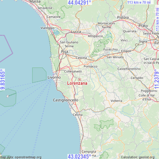
Lorenzana GPS coordinates[2]
43° 32' 7.188" North, 10° 32' 5.172" East
| Map corner | latitude | longitude |
|---|---|---|
| Upper-left | 44.04291°, | 9.83165° |
| Center: | 43.53533°, | 10.53477° |
| Lower-right: | 43.02345°, | 11.2379° |
| Map W x H: | 113.4×113.4 km | = 70.5×70.5mi |
| max Lat: | 47.04031° ⇑59.5% North |
| Lorenzana: | 43.53533° |
| min Lat: | ⇓40.5% South 35.50142° |
| min Long | Lorenzana | max Long |
| 6.69888° | 10.53477° | 18.48682° |
| W 37.6%⇐ | ⇒62.4% E |
Elevation
Elevation of Lorenzana is 117 m = 384 ft, and this is 189.7 m = 622 ft below average elevation for this country.
| Max E: |
2085 m = 6841 ft | 66.7% |
| Avg. | 306.7 m = 1006 ft | |
| Lorenzana | 117 m = 384 ft | |
Min E: |
-4 m = -13 ft | 33.3% |
See also: Italy elevation on elevation.city.
Geographical zone
Lorenzana is located in North temperate zone (between Tropic of Cancer and the Arctic Circle). Distance of this Northern Tropic circle is 2234.8 km =1388.6 mi to South.| Distance of | km | miles | from Lorenzana |
|---|---|---|---|
| North Pole | 5166.4 | 3210.3 | to North |
| Arctic Circle | 2560.5 | 1591 | to North |
| Tropic Cancer | 2234.8 | 1388.6 | to South |
| Equator | 4840.7 | 3007.9 | to South |


Nearby cities:
15 places around Lorenzana: (largest is in red/bold)
• Casciana Terme
6.8 km =4.2 mi,  98°
98°
• Cenaia
7.9 km =4.9 mi,  0°
0°
• Chianni
10.5 km =6.5 mi,  124°
124°
• Collesalvetti
7.8 km =4.8 mi,  322°
322°
• Crespina
4.8 km =3 mi,  29°
29°
• Fauglia
4.3 km =2.7 mi,  337°
337°
• Gabbro
9.5 km =5.9 mi,  231°
231°
• Lari
5.7 km =3.5 mi,  53°
53°
• Lavaiano
11.2 km =7 mi,  20°
20°
• Le Casine-Perignano-Spinelli
8.2 km =5.1 mi, 28°
• Nugola
8.9 km =5.5 mi,  302°
302°
• Orciano Pisano
4.9 km =3 mi,  202°
202°
• Quattro Strade
8.3 km =5.2 mi, 20°
• Santa Luce
7.5 km =4.7 mi,  162°
162°
• Vicarello
10.2 km =6.3 mi,  326°
326°
Sources, notices
• [Note1] Compared only with cities in Italy existing in our database
• [Src1] Map data: © OpenStreetMap contributors (CC-BY-SA)
• [Src2] Other city data from geonames.org with taken over terms of usage.
• [Src3] Geographical zone / Annual Mean Temperature by Robert A. Rohde @ Wikipedia
