Qualso geodata
Qualso (Friuli Venezia Giulia) is a populated place; located in Italy in Europe/Rome (GMT+2) time zone. With population of 652 people, there are 8620 cities with bigger population in this country. Compared to other cities in Italy, 95.7% of cities are located further ↓South; 70.8% of cities are located further ←West and 55.6% of cities have higher elevation than Qualso. Note1
Administrative division(s):
- Level 1: Friuli Venezia Giulia
- Level 2: Provincia di Udine
- Level 3: Reana del Rojale


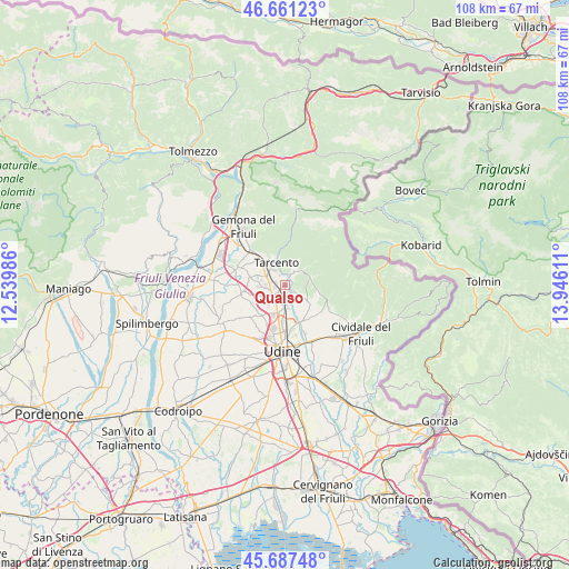
Qualso GPS coordinates[2]
46° 10' 35.436" North, 13° 14' 34.728" East
| Map corner | latitude | longitude |
|---|---|---|
| Upper-left | 46.66123°, | 12.53986° |
| Center: | 46.17651°, | 13.24298° |
| Lower-right: | 45.68748°, | 13.94611° |
| Map W x H: | 108.3×108.3 km | = 67.3×67.3mi |
| max Lat: | 47.04031° ⇑4.3% North |
| Qualso: | 46.17651° |
| min Lat: | ⇓95.7% South 35.50142° |
| min Long | Qualso | max Long |
| 6.69888° | 13.24298° | 18.48682° |
| W 70.8%⇐ | ⇒29.2% E |
Elevation
Elevation of Qualso is 198 m = 650 ft, and this is 108.7 m = 357 ft below average elevation for this country.
| Max E: |
2085 m = 6841 ft | 55.6% |
| Avg. | 306.7 m = 1006 ft | |
| Qualso | 198 m = 650 ft | |
Min E: |
-4 m = -13 ft | 44.4% |
See also: Italy elevation on elevation.city.
Geographical zone
Qualso is located in North temperate zone (between Tropic of Cancer and the Arctic Circle). Distance of this North polar circle is 2266.8 km =1408.5 mi to North.| Distance of | km | miles | from Qualso |
|---|---|---|---|
| North Pole | 4872.7 | 3027.8 | to North |
| Arctic Circle | 2266.8 | 1408.5 | to North |
| Tropic Cancer | 2528.4 | 1571.1 | to South |
| Equator | 5134.3 | 3190.3 | to South |


Nearby cities:
15 places around Qualso: (largest is in red/bold)
• Attimis
5.5 km =3.4 mi,  73°
73°
• Bueriis
6.3 km =3.9 mi,  309°
309°
• Cassacco
3.9 km =2.4 mi,  265°
265°
• Magnano in Riviera
6.4 km =4 mi,  324°
324°
• Nimis
3.9 km =2.4 mi,  29°
29°
• Primulacco
4.4 km =2.7 mi,  144°
144°
• Ravosa-Magredis
5.3 km =3.3 mi,  121°
121°
• Reana del Roiale
4.6 km =2.9 mi,  199°
199°
• Reana del Rojale
3.7 km =2.3 mi,  175°
175°
• Savorgnano del Torre
2.6 km =1.6 mi, 119°
• Tarcento
4.5 km =2.8 mi,  331°
331°
• Tavagnacco
7.6 km =4.7 mi,  191°
191°
• Treppo Grande
7.4 km =4.6 mi,  290°
290°
• Tricesimo
2.8 km =1.7 mi,  229°
229°
• Vendoglio-Carvacco
6.9 km =4.3 mi, 272°
Sources, notices
• [Note1] Compared only with cities in Italy existing in our database
• [Src1] Map data: © OpenStreetMap contributors (CC-BY-SA)
• [Src2] Other city data from geonames.org with taken over terms of usage.
• [Src3] Geographical zone / Annual Mean Temperature by Robert A. Rohde @ Wikipedia
