Procida geodata
Procida (Campania) is a seat of a third-order administrative division; located in Italy in Europe/Rome (GMT+2) time zone. With population of 10,228 people, there are 927 cities with bigger population in this country. Compared to other cities in Italy, 81.8% of cities are located further ↑North; 78.3% of cities are located further ←West and 84.1% of cities have higher elevation than Procida. Note1


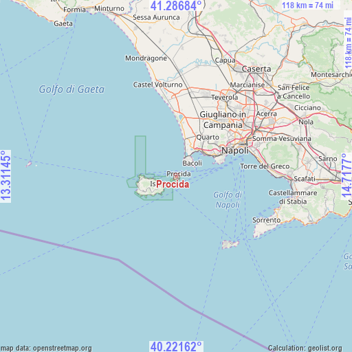
Procida GPS coordinates[2]
40° 45' 22.896" North, 14° 0' 52.452" East
| Map corner | latitude | longitude |
|---|---|---|
| Upper-left | 41.28684°, | 13.31145° |
| Center: | 40.75636°, | 14.01457° |
| Lower-right: | 40.22162°, | 14.7177° |
| Map W x H: | 118.4×118.4 km | = 73.6×73.6mi |
| max Lat: | 47.04031° ⇑81.8% North |
| Procida: | 40.75636° |
| min Lat: | ⇓18.2% South 35.50142° |
| min Long | Procida | max Long |
| 6.69888° | 14.01457° | 18.48682° |
| W 78.3%⇐ | ⇒21.7% E |
Elevation
Elevation of Procida is 34 m = 112 ft, and this is 272.7 m = 895 ft below average elevation for this country.
| Max E: |
2085 m = 6841 ft | 84.1% |
| Avg. | 306.7 m = 1006 ft | |
| Procida | 34 m = 112 ft | |
Min E: |
-4 m = -13 ft | 15.9% |
See also: Italy elevation on elevation.city.
Geographical zone
Procida is located in North temperate zone (between Tropic of Cancer and the Arctic Circle). Distance of this Northern Tropic circle is 1925.8 km =1196.6 mi to South.| Distance of | km | miles | from Procida |
|---|---|---|---|
| North Pole | 5475.4 | 3402.3 | to North |
| Arctic Circle | 2869.5 | 1783 | to North |
| Tropic Cancer | 1925.8 | 1196.6 | to South |
| Equator | 4531.7 | 2815.9 | to South |


Nearby cities:
15 places around Procida: (largest is in red/bold)
• Bacoli
6.7 km =4.2 mi,  47°
47°
• Bagnoli
14.4 km =8.9 mi,  63°
63°
• Barano d'Ischia
8.8 km =5.5 mi,  238°
238°
• Casamicciola Terme
8.7 km =5.4 mi,  262°
262°
• Country Park
15 km =9.3 mi,  20°
20°
• Forio
13.2 km =8.2 mi, 260°
• Ischia
5.9 km =3.7 mi,  249°
249°
• Ischia Porto
5.7 km =3.5 mi, 250°
• Lacco Ameno
10.8 km =6.7 mi,  265°
265°
• Masseria Vecchia Ovest
15.4 km =9.6 mi, 16°
• Monte di Procida
5.5 km =3.4 mi,  32°
32°
• Monterusciello
13.8 km =8.6 mi, 24°
• Pozzuoli
11.9 km =7.4 mi, 34°
• Sant'Angelo
12.1 km =7.5 mi, 237°
• Serrara Fontana
11 km =6.8 mi, 245°
Sources, notices
• [Note1] Compared only with cities in Italy existing in our database
• [Src1] Map data: © OpenStreetMap contributors (CC-BY-SA)
• [Src2] Other city data from geonames.org with taken over terms of usage.
• [Src3] Geographical zone / Annual Mean Temperature by Robert A. Rohde @ Wikipedia
