Preganziol geodata
Preganziol (Veneto) is a seat of a third-order administrative division; located in Italy in Europe/Rome (GMT+2) time zone. With population of 6,674 people, there are 1475 cities with bigger population in this country. Compared to other cities in Italy, 77.1% of cities are located further ↓South; 59.1% of cities are located further ←West and 93.6% of cities have higher elevation than Preganziol. Note1


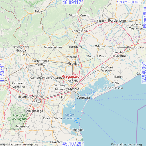
Preganziol GPS coordinates[2]
45° 36' 5.004" North, 12° 14' 13.992" East
| Map corner | latitude | longitude |
|---|---|---|
| Upper-left | 46.09117°, | 11.5341° |
| Center: | 45.60139°, | 12.23722° |
| Lower-right: | 45.10729°, | 12.94035° |
| Map W x H: | 109.4×109.4 km | = 68×68mi |
| max Lat: | 47.04031° ⇑22.9% North |
| Preganziol: | 45.60139° |
| min Lat: | ⇓77.1% South 35.50142° |
| min Long | Preganziol | max Long |
| 6.69888° | 12.23722° | 18.48682° |
| W 59.1%⇐ | ⇒40.9% E |
Elevation
Elevation of Preganziol is 11 m = 36 ft, and this is 295.7 m = 970 ft below average elevation for this country.
| Max E: |
2085 m = 6841 ft | 93.6% |
| Avg. | 306.7 m = 1006 ft | |
| Preganziol | 11 m = 36 ft | |
Min E: |
-4 m = -13 ft | 6.4% |
See also: Italy elevation on elevation.city.
Geographical zone
Preganziol is located in North temperate zone (between Tropic of Cancer and the Arctic Circle). Distance of this North polar circle is 2330.8 km =1448.3 mi to North.| Distance of | km | miles | from Preganziol |
|---|---|---|---|
| North Pole | 4936.7 | 3067.5 | to North |
| Arctic Circle | 2330.8 | 1448.3 | to North |
| Tropic Cancer | 2464.5 | 1531.4 | to South |
| Equator | 5070.4 | 3150.6 | to South |


Nearby cities:
15 places around Preganziol: (largest is in red/bold)
• Bonisiolo
6.6 km =4.1 mi,  108°
108°
• Borgo Verde
1.8 km =1.1 mi,  94°
94°
• Campocroce
2.4 km =1.5 mi,  219°
219°
• Casale sul Sile
7 km =4.3 mi, 94°
• Casier
6.3 km =3.9 mi,  43°
43°
• Conscio
3.9 km =2.4 mi,  63°
63°
• Dosson
4.1 km =2.5 mi,  18°
18°
• Frescada
3 km =1.9 mi,  359°
359°
• Marcon-Gaggio-Colmello
6.3 km =3.9 mi,  130°
130°
• Mogliano Veneto
5.1 km =3.2 mi,  174°
174°
• Peseggia-Gardigiano
6.3 km =3.9 mi,  225°
225°
• Sambughe
1.7 km =1.1 mi,  240°
240°
• Treviso
7.3 km =4.5 mi,  2°
2°
• Zerman
3.5 km =2.2 mi,  136°
136°
• Zero Branco
5.7 km =3.5 mi,  267°
267°
Sources, notices
• [Note1] Compared only with cities in Italy existing in our database
• [Src1] Map data: © OpenStreetMap contributors (CC-BY-SA)
• [Src2] Other city data from geonames.org with taken over terms of usage.
• [Src3] Geographical zone / Annual Mean Temperature by Robert A. Rohde @ Wikipedia
