Pontecurone geodata
Pontecurone (Piedmont) is a seat of a third-order administrative division; located in Italy in Europe/Rome (GMT+2) time zone. With population of 3,839 people, there are 2488 cities with bigger population in this country. Compared to other cities in Italy, 59.1% of cities are located further ↓South; 82.2% of cities are located further →East and 68.8% of cities have higher elevation than Pontecurone. Note1
Administrative division(s):
- Level 1: Piedmont
- Level 2: Provincia di Alessandria
- Level 3: Pontecurone


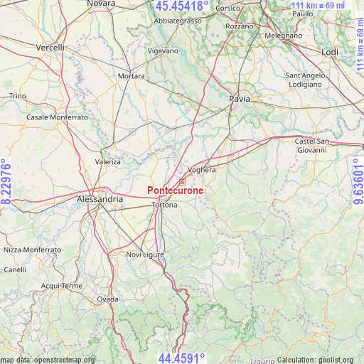
Pontecurone GPS coordinates[2]
44° 57' 31.68" North, 8° 55' 58.404" East
| Map corner | latitude | longitude |
|---|---|---|
| Upper-left | 45.45418°, | 8.22976° |
| Center: | 44.9588°, | 8.93289° |
| Lower-right: | 44.4591°, | 9.63601° |
| Map W x H: | 110.6×110.6 km | = 68.7×68.7mi |
| max Lat: | 47.04031° ⇑40.9% North |
| Pontecurone: | 44.9588° |
| min Lat: | ⇓59.1% South 35.50142° |
| min Long | Pontecurone | max Long |
| 6.69888° | 8.93289° | 18.48682° |
| W 17.8%⇐ | ⇒82.2% E |
Elevation
Elevation of Pontecurone is 104 m = 341 ft, and this is 202.7 m = 665 ft below average elevation for this country.
| Max E: |
2085 m = 6841 ft | 68.8% |
| Avg. | 306.7 m = 1006 ft | |
| Pontecurone | 104 m = 341 ft | |
Min E: |
-4 m = -13 ft | 31.2% |
See also: Italy elevation on elevation.city.
Geographical zone
Pontecurone is located in North temperate zone (between Tropic of Cancer and the Arctic Circle). Distance of this Northern Tropic circle is 2393 km =1486.9 mi to South.| Distance of | km | miles | from Pontecurone |
|---|---|---|---|
| North Pole | 5008.1 | 3111.9 | to North |
| Arctic Circle | 2402.2 | 1492.7 | to North |
| Tropic Cancer | 2393 | 1486.9 | to South |
| Equator | 4998.9 | 3106.2 | to South |


Nearby cities:
15 places around Pontecurone: (largest is in red/bold)
• Alzano Scrivia
7.8 km =4.8 mi,  328°
328°
• Casalnoceto
6.5 km =4 mi,  141°
141°
• Casei
5.4 km =3.4 mi,  354°
354°
• Castellar Guidobono
6.1 km =3.8 mi,  168°
168°
• Castelnuovo Scrivia
4.6 km =2.9 mi,  299°
299°
• Molino dei Torti
7.9 km =4.9 mi,  337°
337°
• Monleale
8.9 km =5.5 mi,  158°
158°
• Retorbido
8.2 km =5.1 mi,  96°
96°
• Rivanazzano
7.2 km =4.5 mi,  117°
117°
• Salice Terme
8.8 km =5.5 mi, 123°
• Tortona
8.7 km =5.4 mi,  218°
218°
• Viguzzolo
6 km =3.7 mi,  189°
189°
• Voghera
7.2 km =4.5 mi,  59°
59°
• Volpedo
8.8 km =5.5 mi,  151°
151°
• Volpeglino
7.6 km =4.7 mi, 164°
Sources, notices
• [Note1] Compared only with cities in Italy existing in our database
• [Src1] Map data: © OpenStreetMap contributors (CC-BY-SA)
• [Src2] Other city data from geonames.org with taken over terms of usage.
• [Src3] Geographical zone / Annual Mean Temperature by Robert A. Rohde @ Wikipedia
