Voghera geodata
Voghera (Lombardy) is a seat of a third-order administrative division; located in Italy in Europe/Rome (GMT+2) time zone. With population of 36,054 people, there are 209 cities with bigger population in this country. Compared to other cities in Italy, 59.7% of cities are located further ↓South; 81.1% of cities are located further →East and 69.6% of cities have higher elevation than Voghera. Note1


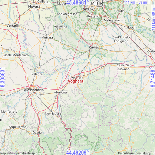
Voghera GPS coordinates[2]
44° 59' 29.436" North, 9° 0' 42.3" East
| Map corner | latitude | longitude |
|---|---|---|
| Upper-left | 45.48661°, | 8.30863° |
| Center: | 44.99151°, | 9.01175° |
| Lower-right: | 44.49209°, | 9.71488° |
| Map W x H: | 110.6×110.6 km | = 68.7×68.7mi |
| max Lat: | 47.04031° ⇑40.3% North |
| Voghera: | 44.99151° |
| min Lat: | ⇓59.7% South 35.50142° |
| min Long | Voghera | max Long |
| 6.69888° | 9.01175° | 18.48682° |
| W 18.9%⇐ | ⇒81.1% E |
Elevation
Elevation of Voghera is 100 m = 328 ft, and this is 206.7 m = 678 ft below average elevation for this country.
| Max E: |
2085 m = 6841 ft | 69.6% |
| Avg. | 306.7 m = 1006 ft | |
| Voghera | 100 m = 328 ft | |
Min E: |
-4 m = -13 ft | 30.4% |
See also: Italy elevation on elevation.city.
Geographical zone
Voghera is located in North temperate zone (between Tropic of Cancer and the Arctic Circle). Distance of this Northern Tropic circle is 2396.7 km =1489.2 mi to South.| Distance of | km | miles | from Voghera |
|---|---|---|---|
| North Pole | 5004.5 | 3109.7 | to North |
| Arctic Circle | 2398.6 | 1490.4 | to North |
| Tropic Cancer | 2396.7 | 1489.2 | to South |
| Equator | 5002.6 | 3108.5 | to South |


Nearby cities:
15 places around Voghera: (largest is in red/bold)
• Bastida de' Dossi
8.9 km =5.5 mi,  307°
307°
• Casalnoceto
9 km =5.6 mi,  194°
194°
• Casei
6.9 km =4.3 mi,  284°
284°
• Cervesina
7.7 km =4.8 mi,  2°
2°
• Codevilla
4.8 km =3 mi,  130°
130°
• Corana
8.6 km =5.3 mi,  337°
337°
• Lungavilla
7.6 km =4.7 mi,  43°
43°
• Montebello
7.2 km =4.5 mi,  82°
82°
• Pizzale
6 km =3.7 mi,  29°
29°
• Pontecurone
7.2 km =4.5 mi,  239°
239°
• Retorbido
5 km =3.1 mi,  156°
156°
• Rivanazzano
6.9 km =4.3 mi,  178°
178°
• Salice Terme
8.6 km =5.3 mi,  172°
172°
• Silvano Pietra
7.4 km =4.6 mi,  315°
315°
• Torrazza Coste
5.3 km =3.3 mi,  106°
106°
Sources, notices
• [Note1] Compared only with cities in Italy existing in our database
• [Src1] Map data: © OpenStreetMap contributors (CC-BY-SA)
• [Src2] Other city data from geonames.org with taken over terms of usage.
• [Src3] Geographical zone / Annual Mean Temperature by Robert A. Rohde @ Wikipedia
