Paullo geodata
Paullo (Lombardy) is a seat of a third-order administrative division; located in Italy in Europe/Rome (GMT+2) time zone. With population of 10,877 people, there are 871 cities with bigger population in this country. Compared to other cities in Italy, 70.8% of cities are located further ↓South; 74.4% of cities are located further →East and 69.7% of cities have higher elevation than Paullo. Note1
Administrative division(s):
- Level 1: Lombardy
- Level 2: Città metropolitana di Milano
- Level 3: Paullo


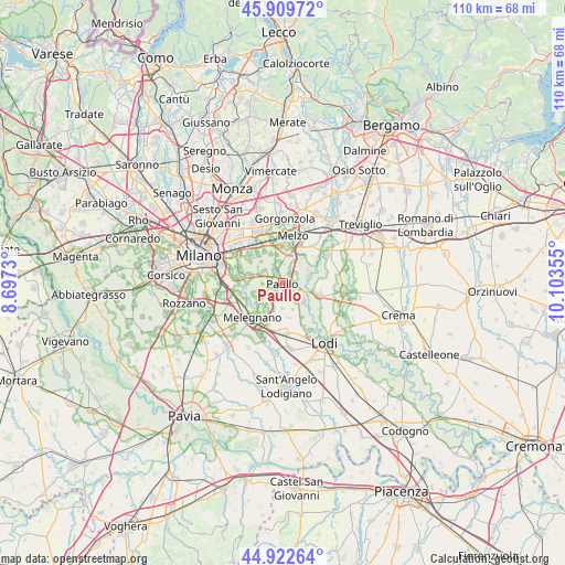
Paullo GPS coordinates[2]
45° 25' 6.024" North, 9° 24' 1.512" East
| Map corner | latitude | longitude |
|---|---|---|
| Upper-left | 45.90972°, | 8.6973° |
| Center: | 45.41834°, | 9.40042° |
| Lower-right: | 44.92264°, | 10.10355° |
| Map W x H: | 109.8×109.8 km | = 68.2×68.2mi |
| max Lat: | 47.04031° ⇑29.2% North |
| Paullo: | 45.41834° |
| min Lat: | ⇓70.8% South 35.50142° |
| min Long | Paullo | max Long |
| 6.69888° | 9.40042° | 18.48682° |
| W 25.6%⇐ | ⇒74.4% E |
Elevation
Elevation of Paullo is 99 m = 325 ft, and this is 207.7 m = 681 ft below average elevation for this country.
| Max E: |
2085 m = 6841 ft | 69.7% |
| Avg. | 306.7 m = 1006 ft | |
| Paullo | 99 m = 325 ft | |
Min E: |
-4 m = -13 ft | 30.3% |
See also: Italy elevation on elevation.city.
Geographical zone
Paullo is located in North temperate zone (between Tropic of Cancer and the Arctic Circle). Distance of this North polar circle is 2351.1 km =1460.9 mi to North.| Distance of | km | miles | from Paullo |
|---|---|---|---|
| North Pole | 4957 | 3080.1 | to North |
| Arctic Circle | 2351.1 | 1460.9 | to North |
| Tropic Cancer | 2444.1 | 1518.7 | to South |
| Equator | 5050 | 3137.9 | to South |


Nearby cities:
15 places around Paullo: (largest is in red/bold)
• Balbiano
5.3 km =3.3 mi,  219°
219°
• Bustighera
4.9 km =3 mi,  245°
245°
• Caleppio
2.3 km =1.4 mi,  321°
321°
• Cassino d'Alberi
3 km =1.9 mi,  194°
194°
• Cervignano d'Adda
5.3 km =3.3 mi,  159°
159°
• Comazzo
5.5 km =3.4 mi,  61°
61°
• Merlino
2.8 km =1.7 mi,  53°
53°
• Mignete
3.6 km =2.2 mi,  137°
137°
• Mombretto
2.8 km =1.7 mi,  282°
282°
• Mulazzano
5.1 km =3.2 mi,  182°
182°
• Pantigliate
4.2 km =2.6 mi,  296°
296°
• Settala
4.1 km =2.5 mi,  345°
345°
• Tribiano
1.9 km =1.2 mi, 252°
• Vigliano-Bettolino
4.7 km =2.9 mi,  290°
290°
• Zelo Buon Persico
2.6 km =1.6 mi,  106°
106°
Sources, notices
• [Note1] Compared only with cities in Italy existing in our database
• [Src1] Map data: © OpenStreetMap contributors (CC-BY-SA)
• [Src2] Other city data from geonames.org with taken over terms of usage.
• [Src3] Geographical zone / Annual Mean Temperature by Robert A. Rohde @ Wikipedia
