Palestro geodata
Palestro (Lombardy) is a seat of a third-order administrative division; located in Italy in Europe/Rome (GMT+2) time zone. With population of 1,838 people, there are 4427 cities with bigger population in this country. Compared to other cities in Italy, 67.5% of cities are located further ↓South; 87.6% of cities are located further →East and 66% of cities have higher elevation than Palestro. Note1


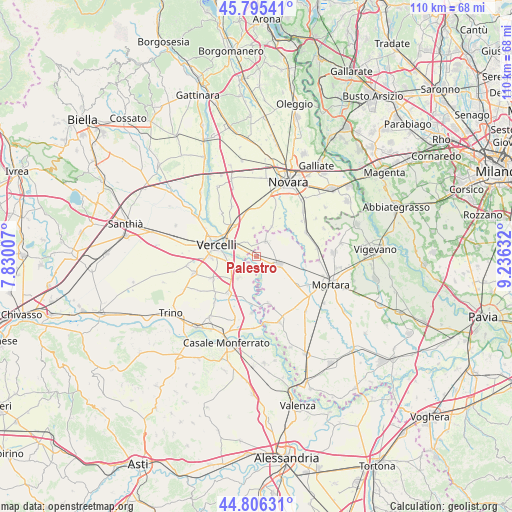
Palestro GPS coordinates[2]
45° 18' 10.872" North, 8° 31' 59.52" East
| Map corner | latitude | longitude |
|---|---|---|
| Upper-left | 45.79541°, | 7.83007° |
| Center: | 45.30302°, | 8.5332° |
| Lower-right: | 44.80631°, | 9.23632° |
| Map W x H: | 110×110 km | = 68.4×68.4mi |
| max Lat: | 47.04031° ⇑32.5% North |
| Palestro: | 45.30302° |
| min Lat: | ⇓67.5% South 35.50142° |
| min Long | Palestro | max Long |
| 6.69888° | 8.5332° | 18.48682° |
| W 12.4%⇐ | ⇒87.6% E |
Elevation
Elevation of Palestro is 121 m = 397 ft, and this is 185.7 m = 609 ft below average elevation for this country.
| Max E: |
2085 m = 6841 ft | 66% |
| Avg. | 306.7 m = 1006 ft | |
| Palestro | 121 m = 397 ft | |
Min E: |
-4 m = -13 ft | 34% |
See also: Italy elevation on elevation.city.
Geographical zone
Palestro is located in North temperate zone (between Tropic of Cancer and the Arctic Circle). Distance of this North polar circle is 2364 km =1468.9 mi to North.| Distance of | km | miles | from Palestro |
|---|---|---|---|
| North Pole | 4969.8 | 3088.1 | to North |
| Arctic Circle | 2364 | 1468.9 | to North |
| Tropic Cancer | 2431.3 | 1510.7 | to South |
| Equator | 5037.2 | 3130 | to South |


Nearby cities:
15 places around Palestro: (largest is in red/bold)
• Borgo Vercelli
8 km =5 mi,  318°
318°
• Cameriano
10.4 km =6.5 mi,  1°
1°
• Caresana
9.3 km =5.8 mi,  193°
193°
• Casalino
6.2 km =3.9 mi,  353°
353°
• Castelnovetto
8.2 km =5.1 mi,  131°
131°
• Confienza
3.7 km =2.3 mi,  32°
32°
• Granozzo con Monticello
7.1 km =4.4 mi, 26°
• Langosco
10.1 km =6.3 mi,  166°
166°
• Pezzana
6 km =3.7 mi,  219°
219°
• Prarolo
4.9 km =3 mi,  241°
241°
• Robbio
4.9 km =3 mi,  108°
108°
• Rosasco
6.9 km =4.3 mi,  148°
148°
• Stroppiana
10.2 km =6.3 mi, 217°
• Vercelli
9.1 km =5.7 mi,  283°
283°
• Vinzaglio
2.5 km =1.6 mi,  334°
334°
Sources, notices
• [Note1] Compared only with cities in Italy existing in our database
• [Src1] Map data: © OpenStreetMap contributors (CC-BY-SA)
• [Src2] Other city data from geonames.org with taken over terms of usage.
• [Src3] Geographical zone / Annual Mean Temperature by Robert A. Rohde @ Wikipedia
