Confienza geodata
Confienza (Lombardy) is a seat of a third-order administrative division; located in Italy in Europe/Rome (GMT+2) time zone. With population of 1,621 people, there are 4845 cities with bigger population in this country. Compared to other cities in Italy, 68.3% of cities are located further ↓South; 87.2% of cities are located further →East and 65.1% of cities have higher elevation than Confienza. Note1


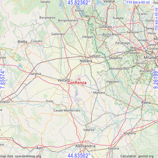
Confienza GPS coordinates[2]
45° 19' 53.328" North, 8° 33' 31.896" East
| Map corner | latitude | longitude |
|---|---|---|
| Upper-left | 45.82362°, | 7.85574° |
| Center: | 45.33148°, | 8.55886° |
| Lower-right: | 44.83502°, | 9.26199° |
| Map W x H: | 109.9×109.9 km | = 68.3×68.3mi |
| max Lat: | 47.04031° ⇑31.7% North |
| Confienza: | 45.33148° |
| min Lat: | ⇓68.3% South 35.50142° |
| min Long | Confienza | max Long |
| 6.69888° | 8.55886° | 18.48682° |
| W 12.8%⇐ | ⇒87.2% E |
Elevation
Elevation of Confienza is 127 m = 417 ft, and this is 179.7 m = 590 ft below average elevation for this country.
| Max E: |
2085 m = 6841 ft | 65.1% |
| Avg. | 306.7 m = 1006 ft | |
| Confienza | 127 m = 417 ft | |
Min E: |
-4 m = -13 ft | 34.9% |
See also: Italy elevation on elevation.city.
Geographical zone
Confienza is located in North temperate zone (between Tropic of Cancer and the Arctic Circle). Distance of this North polar circle is 2360.8 km =1466.9 mi to North.| Distance of | km | miles | from Confienza |
|---|---|---|---|
| North Pole | 4966.7 | 3086.2 | to North |
| Arctic Circle | 2360.8 | 1466.9 | to North |
| Tropic Cancer | 2434.5 | 1512.7 | to South |
| Equator | 5040.4 | 3132 | to South |


Nearby cities:
15 places around Confienza: (largest is in red/bold)
• Borgo Vercelli
7.9 km =4.9 mi,  290°
290°
• Cameriano
7.4 km =4.6 mi,  346°
346°
• Casalino
4 km =2.5 mi,  317°
317°
• Castelnovetto
9.5 km =5.9 mi,  154°
154°
• Granozzo con Monticello
3.4 km =2.1 mi,  19°
19°
• Lumellogno
8.8 km =5.5 mi,  14°
14°
• Nibbiola
8.9 km =5.5 mi,  59°
59°
• Nicorvo
9.9 km =6.2 mi,  120°
120°
• Palestro
3.7 km =2.3 mi,  212°
212°
• Pezzana
9.7 km =6 mi,  216°
216°
• Prarolo
8.4 km =5.2 mi,  228°
228°
• Robbio
5.4 km =3.4 mi, 150°
• Rosasco
9.2 km =5.7 mi,  169°
169°
• Vespolate
8.8 km =5.5 mi,  76°
76°
• Vinzaglio
3.2 km =2 mi,  253°
253°
Sources, notices
• [Note1] Compared only with cities in Italy existing in our database
• [Src1] Map data: © OpenStreetMap contributors (CC-BY-SA)
• [Src2] Other city data from geonames.org with taken over terms of usage.
• [Src3] Geographical zone / Annual Mean Temperature by Robert A. Rohde @ Wikipedia
