Ornavasso geodata
Ornavasso (Piedmont) is a seat of a third-order administrative division; located in Italy in Europe/Rome (GMT+2) time zone. With population of 3,056 people, there are 2993 cities with bigger population in this country. Compared to other cities in Italy, 91.1% of cities are located further ↓South; 88.9% of cities are located further →East and 53.2% of cities have higher elevation than Ornavasso. Note1
Administrative division(s):
- Level 1: Piedmont
- Level 2: Provincia Verbano-Cusio-Ossola
- Level 3: Ornavasso


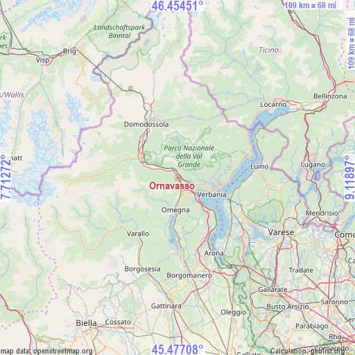
Ornavasso GPS coordinates[2]
45° 58' 4.62" North, 8° 24' 57.024" East
| Map corner | latitude | longitude |
|---|---|---|
| Upper-left | 46.45451°, | 7.71272° |
| Center: | 45.96795°, | 8.41584° |
| Lower-right: | 45.47708°, | 9.11897° |
| Map W x H: | 108.7×108.7 km | = 67.5×67.5mi |
| max Lat: | 47.04031° ⇑8.9% North |
| Ornavasso: | 45.96795° |
| min Lat: | ⇓91.1% South 35.50142° |
| min Long | Ornavasso | max Long |
| 6.69888° | 8.41584° | 18.48682° |
| W 11.1%⇐ | ⇒88.9% E |
Elevation
Elevation of Ornavasso is 215 m = 705 ft, and this is 91.7 m = 301 ft below average elevation for this country.
| Max E: |
2085 m = 6841 ft | 53.2% |
| Avg. | 306.7 m = 1006 ft | |
| Ornavasso | 215 m = 705 ft | |
Min E: |
-4 m = -13 ft | 46.8% |
See also: Italy elevation on elevation.city.
Geographical zone
Ornavasso is located in North temperate zone (between Tropic of Cancer and the Arctic Circle). Distance of this North polar circle is 2290 km =1422.9 mi to North.| Distance of | km | miles | from Ornavasso |
|---|---|---|---|
| North Pole | 4895.9 | 3042.2 | to North |
| Arctic Circle | 2290 | 1422.9 | to North |
| Tropic Cancer | 2505.2 | 1556.7 | to South |
| Equator | 5111.2 | 3176 | to South |


Nearby cities:
15 places around Ornavasso: (largest is in red/bold)
• Anzola d'Ossola
5.9 km =3.7 mi,  293°
293°
• Bieno
7.7 km =4.8 mi,  103°
103°
• Casale Corte Cerro
5.8 km =3.6 mi,  181°
181°
• Cossogno
7.3 km =4.5 mi,  93°
93°
• Feriolo
6.4 km =4 mi,  130°
130°
• Fondotoce
6.4 km =4 mi,  111°
111°
• Gabbio-Cereda-Ramate
6.5 km =4 mi, 176°
• Germagno
8.7 km =5.4 mi,  194°
194°
• Gravellona Toce
4.6 km =2.9 mi,  163°
163°
• Loreglia
7.6 km =4.7 mi,  206°
206°
• Mergozzo
3 km =1.9 mi, 102°
• Miazzina
8.3 km =5.2 mi,  84°
84°
• Premosello-Chiovenda
7.8 km =4.8 mi,  300°
300°
• San Bernardino Verbano
8.1 km =5 mi, 99°
• Santino
8.1 km =5 mi, 99°
Sources, notices
• [Note1] Compared only with cities in Italy existing in our database
• [Src1] Map data: © OpenStreetMap contributors (CC-BY-SA)
• [Src2] Other city data from geonames.org with taken over terms of usage.
• [Src3] Geographical zone / Annual Mean Temperature by Robert A. Rohde @ Wikipedia
