Nuoro geodata
Nuoro (Sardinia) is a seat of a second-order administrative division; located in Italy in Europe/Rome (GMT+2) time zone. With population of 35,948 people, there are 210 cities with bigger population in this country. Compared to other cities in Italy, 85.4% of cities are located further ↑North; 75.9% of cities are located further →East and 80.7% of cities have lower elevation than Nuoro. Note1


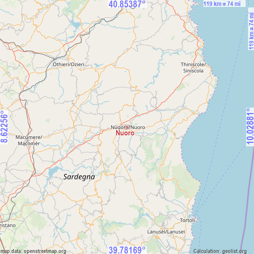
Nuoro GPS coordinates[2]
40° 19' 11.676" North, 9° 19' 32.448" East
| Map corner | latitude | longitude |
|---|---|---|
| Upper-left | 40.85387°, | 8.62256° |
| Center: | 40.31991°, | 9.32568° |
| Lower-right: | 39.78169°, | 10.02881° |
| Map W x H: | 119.2×119.2 km | = 74.1×74.1mi |
| max Lat: | 47.04031° ⇑85.4% North |
| Nuoro: | 40.31991° |
| min Lat: | ⇓14.6% South 35.50142° |
| min Long | Nuoro | max Long |
| 6.69888° | 9.32568° | 18.48682° |
| W 24.1%⇐ | ⇒75.9% E |
Elevation
Elevation of Nuoro is 535 m = 1755 ft, and this is 228.3 m = 749 ft above average elevation for this country.
| Max E: |
2085 m = 6841 ft | 19.3% |
| Nuoro | 535 m 1755 ft | |
| Avg. | 306.7 m = 1006 ft | |
Min E: |
-4 m = -13 ft | 80.7% |
See also: Italy elevation on elevation.city.
Geographical zone
Nuoro is located in North temperate zone (between Tropic of Cancer and the Arctic Circle). Distance of this Northern Tropic circle is 1877.2 km =1166.4 mi to South.| Distance of | km | miles | from Nuoro |
|---|---|---|---|
| North Pole | 5523.9 | 3432.4 | to North |
| Arctic Circle | 2918 | 1813.2 | to North |
| Tropic Cancer | 1877.2 | 1166.4 | to South |
| Equator | 4483.2 | 2785.7 | to South |


Nearby cities:
15 places around Nuoro: (largest is in red/bold)
• Benetutti
20.3 km =12.6 mi,  318°
318°
• Bitti
18.4 km =11.4 mi,  15°
15°
• Gavoi
20.9 km =13 mi,  212°
212°
• Lodine
21 km =13 mi, 205°
• Mamoiada
12.3 km =7.6 mi,  197°
197°
• Nule
19.6 km =12.2 mi, 324°
• Oliena
8.1 km =5 mi,  126°
126°
• Ollolai
21 km =13 mi,  216°
216°
• Onanì
20.9 km =13 mi,  28°
28°
• Oniferi
14.2 km =8.8 mi,  247°
247°
• Orani
14.4 km =8.9 mi,  238°
238°
• Orgosolo
13 km =8.1 mi,  169°
169°
• Orotelli
17.4 km =10.8 mi,  265°
265°
• Orune
10.5 km =6.5 mi, 20°
• Sarule
16.9 km =10.5 mi,  232°
232°
Sources, notices
• [Note1] Compared only with cities in Italy existing in our database
• [Src1] Map data: © OpenStreetMap contributors (CC-BY-SA)
• [Src2] Other city data from geonames.org with taken over terms of usage.
• [Src3] Geographical zone / Annual Mean Temperature by Robert A. Rohde @ Wikipedia
