Lodine geodata
Lodine (Sardinia) is a seat of a third-order administrative division; located in Italy in Europe/Rome (GMT+2) time zone. With population of 349 people, there are 10483 cities with bigger population in this country. Compared to other cities in Italy, 86.7% of cities are located further ↑North; 77.7% of cities are located further →East and 95% of cities have lower elevation than Lodine. Note1


Lodine GPS coordinates[2]
40° 8' 57.336" North, 9° 13' 7.428" East
| Map corner | latitude | longitude |
|---|---|---|
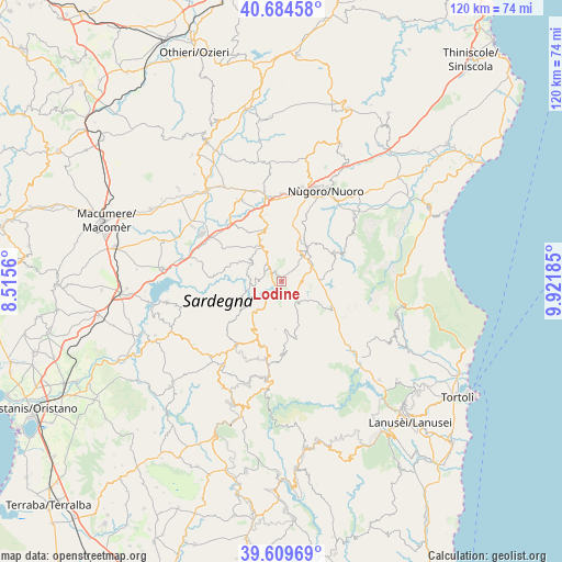
| Upper-left | 40.68458°, | 8.5156° |
| Center: | 40.14926°, | 9.21873° |
| Lower-right: | 39.60969°, | 9.92185° |
| Map W x H: | 119.5×119.5 km | = 74.3×74.3mi |
| max Lat: | 47.04031° ⇑86.7% North |
| Lodine: | 40.14926° |
| min Lat: | ⇓13.3% South 35.50142° |
| min Long | Lodine | max Long |
| 6.69888° | 9.21873° | 18.48682° |
| W 22.3%⇐ | ⇒77.7% E |
Elevation
Elevation of Lodine is 873 m = 2864 ft, and this is 566.3 m = 1858 ft above average elevation for this country.
| Max E: |
2085 m = 6841 ft | 5% |
| Lodine | 873 m 2864 ft | |
| Avg. | 306.7 m = 1006 ft | |
Min E: |
-4 m = -13 ft | 95% |
See also: Italy elevation on elevation.city.
Geographical zone
Lodine is located in North temperate zone (between Tropic of Cancer and the Arctic Circle). Distance of this Northern Tropic circle is 1858.3 km =1154.7 mi to South.| Distance of | km | miles | from Lodine |
|---|---|---|---|
| North Pole | 5542.9 | 3444.2 | to North |
| Arctic Circle | 2937 | 1825 | to North |
| Tropic Cancer | 1858.3 | 1154.7 | to South |
| Equator | 4464.2 | 2773.9 | to South |


Nearby cities:
15 places around Lodine: (largest is in red/bold)
• Austis
14.1 km =8.8 mi,  231°
231°
• Desulo
15 km =9.3 mi,  176°
176°
• Fonni
4.5 km =2.8 mi,  138°
138°
• Gavoi
2.4 km =1.5 mi,  303°
303°
• Mamoiada
9.1 km =5.7 mi,  36°
36°
• Ollolai
4.1 km =2.5 mi, 300°
• Olzai
7.1 km =4.4 mi, 301°
• Oniferi
14.2 km =8.8 mi,  343°
343°
• Orani
11.9 km =7.4 mi, 344°
• Orgosolo
13.1 km =8.1 mi,  61°
61°
• Ovodda
7.8 km =4.8 mi,  219°
219°
• Sarule
9.8 km =6.1 mi,  333°
333°
• Teti
10.2 km =6.3 mi,  235°
235°
• Tiana
10.9 km =6.8 mi,  213°
213°
• Tonara
14.4 km =8.9 mi,  195°
195°
Sources, notices
• [Note1] Compared only with cities in Italy existing in our database
• [Src1] Map data: © OpenStreetMap contributors (CC-BY-SA)
• [Src2] Other city data from geonames.org with taken over terms of usage.
• [Src3] Geographical zone / Annual Mean Temperature by Robert A. Rohde @ Wikipedia
