Nerola geodata
Nerola (Latium) is a seat of a third-order administrative division; located in Italy in Europe/Rome (GMT+2) time zone. With population of 906 people, there are 7113 cities with bigger population in this country. Compared to other cities in Italy, 69% of cities are located further ↑North; 66% of cities are located further ←West and 73% of cities have lower elevation than Nerola. Note1
Administrative division(s):
- Level 1: Latium
- Level 2: Città metropolitana di Roma Capitale
- Level 3: Nerola


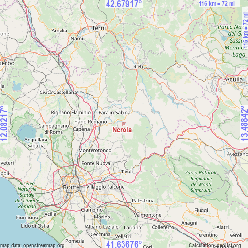
Nerola GPS coordinates[2]
42° 9' 36.396" North, 12° 47' 7.044" East
| Map corner | latitude | longitude |
|---|---|---|
| Upper-left | 42.67917°, | 12.08217° |
| Center: | 42.16011°, | 12.78529° |
| Lower-right: | 41.63676°, | 13.48842° |
| Map W x H: | 115.9×115.9 km | = 72×72mi |
| max Lat: | 47.04031° ⇑69% North |
| Nerola: | 42.16011° |
| min Lat: | ⇓31% South 35.50142° |
| min Long | Nerola | max Long |
| 6.69888° | 12.78529° | 18.48682° |
| W 66%⇐ | ⇒34% E |
Elevation
Elevation of Nerola is 425 m = 1394 ft, and this is 118.3 m = 388 ft above average elevation for this country.
| Max E: |
2085 m = 6841 ft | 27% |
| Nerola | 425 m 1394 ft | |
| Avg. | 306.7 m = 1006 ft | |
Min E: |
-4 m = -13 ft | 73% |
See also: Italy elevation on elevation.city.
Geographical zone
Nerola is located in North temperate zone (between Tropic of Cancer and the Arctic Circle). Distance of this Northern Tropic circle is 2081.8 km =1293.6 mi to South.| Distance of | km | miles | from Nerola |
|---|---|---|---|
| North Pole | 5319.3 | 3305.3 | to North |
| Arctic Circle | 2713.4 | 1686 | to North |
| Tropic Cancer | 2081.8 | 1293.6 | to South |
| Equator | 4687.8 | 2912.9 | to South |


Nearby cities:
15 places around Nerola: (largest is in red/bold)
• Acquaviva
3.5 km =2.2 mi,  276°
276°
• Borgo Quinzio
6 km =3.7 mi,  273°
273°
• Canneto
4.9 km =3 mi,  305°
305°
• Casali
5.1 km =3.2 mi,  9°
9°
• Corese Terra
6.2 km =3.9 mi, 280°
• Fara in Sabina
7 km =4.3 mi,  319°
319°
• Frasso Sabino
7.9 km =4.9 mi, 12°
• Monteflavio
6.8 km =4.2 mi,  146°
146°
• Montelibretti
4.7 km =2.9 mi,  234°
234°
• Montorio Romano
3 km =1.9 mi, 148°
• Moricone
5 km =3.1 mi,  192°
192°
• Poggio Nativo
6.5 km =4 mi, 8°
• Scandriglia
4.6 km =2.9 mi,  88°
88°
• Talocci
8 km =5 mi,  294°
294°
• Toffia
6.4 km =4 mi,  337°
337°
Sources, notices
• [Note1] Compared only with cities in Italy existing in our database
• [Src1] Map data: © OpenStreetMap contributors (CC-BY-SA)
• [Src2] Other city data from geonames.org with taken over terms of usage.
• [Src3] Geographical zone / Annual Mean Temperature by Robert A. Rohde @ Wikipedia
