Canneto geodata
Canneto (Latium) is a populated place; located in Italy in Europe/Rome (GMT+2) time zone. With population of 568 people, there are 9278 cities with bigger population in this country. Compared to other cities in Italy, 68.8% of cities are located further ↑North; 65.4% of cities are located further ←West and 52.2% of cities have lower elevation than Canneto. Note1


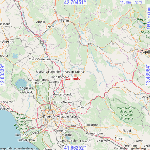
Canneto GPS coordinates[2]
42° 11' 8.376" North, 12° 44' 11.436" East
| Map corner | latitude | longitude |
|---|---|---|
| Upper-left | 42.70451°, | 12.03339° |
| Center: | 42.18566°, | 12.73651° |
| Lower-right: | 41.66252°, | 13.43964° |
| Map W x H: | 115.9×115.9 km | = 72×72mi |
| max Lat: | 47.04031° ⇑68.8% North |
| Canneto: | 42.18566° |
| min Lat: | ⇓31.2% South 35.50142° |
| min Long | Canneto | max Long |
| 6.69888° | 12.73651° | 18.48682° |
| W 65.4%⇐ | ⇒34.6% E |
Elevation
Elevation of Canneto is 248 m = 814 ft, and this is 58.7 m = 193 ft below average elevation for this country.
| Max E: |
2085 m = 6841 ft | 47.8% |
| Avg. | 306.7 m = 1006 ft | |
| Canneto | 248 m = 814 ft | |
Min E: |
-4 m = -13 ft | 52.2% |
See also: Italy elevation on elevation.city.
Geographical zone
Canneto is located in North temperate zone (between Tropic of Cancer and the Arctic Circle). Distance of this Northern Tropic circle is 2084.7 km =1295.4 mi to South.| Distance of | km | miles | from Canneto |
|---|---|---|---|
| North Pole | 5316.5 | 3303.5 | to North |
| Arctic Circle | 2710.6 | 1684.3 | to North |
| Tropic Cancer | 2084.7 | 1295.4 | to South |
| Equator | 4690.6 | 2914.6 | to South |


Nearby cities:
15 places around Canneto: (largest is in red/bold)
• Acquaviva
2.5 km =1.6 mi,  167°
167°
• Borgo Quinzio
3.2 km =2 mi,  218°
218°
• Borgo Santa Maria
5.8 km =3.6 mi,  232°
232°
• Casali
5.4 km =3.4 mi,  65°
65°
• Castelnuovo di Farfa
5.2 km =3.2 mi,  6°
6°
• Corese Terra
2.7 km =1.7 mi, 230°
• Fara in Sabina
2.6 km =1.6 mi,  347°
347°
• Frasso Sabino
7.5 km =4.7 mi,  49°
49°
• Mompeo
7 km =4.3 mi, 9°
• Montelibretti
5.6 km =3.5 mi,  178°
178°
• Montopoli in Sabina
7.6 km =4.7 mi,  331°
331°
• Nerola
4.9 km =3 mi,  125°
125°
• Poggio Nativo
6.1 km =3.8 mi, 54°
• Talocci
3.4 km =2.1 mi,  277°
277°
• Toffia
3.4 km =2.1 mi,  26°
26°
Sources, notices
• [Note1] Compared only with cities in Italy existing in our database
• [Src1] Map data: © OpenStreetMap contributors (CC-BY-SA)
• [Src2] Other city data from geonames.org with taken over terms of usage.
• [Src3] Geographical zone / Annual Mean Temperature by Robert A. Rohde @ Wikipedia
