Mossa geodata
Mossa (Friuli Venezia Giulia) is a seat of a third-order administrative division; located in Italy in Europe/Rome (GMT+2) time zone. With population of 1,659 people, there are 4760 cities with bigger population in this country. Compared to other cities in Italy, 90.2% of cities are located further ↓South; 74.2% of cities are located further ←West and 78.3% of cities have higher elevation than Mossa. Note1
Administrative division(s):
- Level 1: Friuli Venezia Giulia
- Level 2: Provincia di Gorizia
- Level 3: Mossa


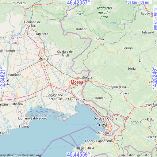
Mossa GPS coordinates[2]
45° 56' 12.264" North, 13° 32' 57.588" East
| Map corner | latitude | longitude |
|---|---|---|
| Upper-left | 46.42357°, | 12.84621° |
| Center: | 45.93674°, | 13.54933° |
| Lower-right: | 45.44559°, | 14.25246° |
| Map W x H: | 108.7×108.7 km | = 67.5×67.5mi |
| max Lat: | 47.04031° ⇑9.8% North |
| Mossa: | 45.93674° |
| min Lat: | ⇓90.2% South 35.50142° |
| min Long | Mossa | max Long |
| 6.69888° | 13.54933° | 18.48682° |
| W 74.2%⇐ | ⇒25.8% E |
Elevation
Elevation of Mossa is 58 m = 190 ft, and this is 248.7 m = 816 ft below average elevation for this country.
| Max E: |
2085 m = 6841 ft | 78.3% |
| Avg. | 306.7 m = 1006 ft | |
| Mossa | 58 m = 190 ft | |
Min E: |
-4 m = -13 ft | 21.7% |
See also: Italy elevation on elevation.city.
Geographical zone
Mossa is located in North temperate zone (between Tropic of Cancer and the Arctic Circle). Distance of this North polar circle is 2293.5 km =1425.1 mi to North.| Distance of | km | miles | from Mossa |
|---|---|---|---|
| North Pole | 4899.4 | 3044.3 | to North |
| Arctic Circle | 2293.5 | 1425.1 | to North |
| Tropic Cancer | 2501.8 | 1554.5 | to South |
| Equator | 5107.7 | 3173.8 | to South |


Nearby cities:
15 places around Mossa: (largest is in red/bold)
• Brazzano
8.5 km =5.3 mi,  300°
300°
• Capriva del Friuli
2.8 km =1.7 mi,  279°
279°
• Cormons
6.7 km =4.2 mi,  287°
287°
• Farra d'Isonzo
4.1 km =2.5 mi,  218°
218°
• Fogliano
9.5 km =5.9 mi,  213°
213°
• Gorizia
5.6 km =3.5 mi,  85°
85°
• Gradisca d'Isonzo
6.1 km =3.8 mi, 216°
• Mariano del Friuli
7.4 km =4.6 mi,  250°
250°
• Moraro
4.2 km =2.6 mi,  259°
259°
• Poggio Terzarmata
5.9 km =3.7 mi,  202°
202°
• Romans d'Isonzo
9.9 km =6.2 mi,  236°
236°
• Sagrado
8.6 km =5.3 mi, 215°
• San Floriano del Collio
5.8 km =3.6 mi,  31°
31°
• San Lorenzo Isontino
2 km =1.2 mi, 248°
• Savogna d'Isonzo
3.9 km =2.4 mi,  143°
143°
Sources, notices
• [Note1] Compared only with cities in Italy existing in our database
• [Src1] Map data: © OpenStreetMap contributors (CC-BY-SA)
• [Src2] Other city data from geonames.org with taken over terms of usage.
• [Src3] Geographical zone / Annual Mean Temperature by Robert A. Rohde @ Wikipedia
