Sagrado geodata
Sagrado (Friuli Venezia Giulia) is a seat of a third-order administrative division; located in Italy in Europe/Rome (GMT+2) time zone. With population of 1,300 people, there are 5635 cities with bigger population in this country. Compared to other cities in Italy, 88.4% of cities are located further ↓South; 73.4% of cities are located further ←West and 88.3% of cities have higher elevation than Sagrado. Note1
Administrative division(s):
- Level 1: Friuli Venezia Giulia
- Level 2: Provincia di Gorizia
- Level 3: Sagrado


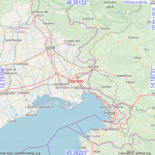
Sagrado GPS coordinates[2]
45° 52' 26.148" North, 13° 29' 3.048" East
| Map corner | latitude | longitude |
|---|---|---|
| Upper-left | 46.36132°, | 12.78106° |
| Center: | 45.87393°, | 13.48418° |
| Lower-right: | 45.38223°, | 14.18731° |
| Map W x H: | 108.9×108.9 km | = 67.7×67.7mi |
| max Lat: | 47.04031° ⇑11.6% North |
| Sagrado: | 45.87393° |
| min Lat: | ⇓88.4% South 35.50142° |
| min Long | Sagrado | max Long |
| 6.69888° | 13.48418° | 18.48682° |
| W 73.4%⇐ | ⇒26.6% E |
Elevation
Elevation of Sagrado is 22 m = 72 ft, and this is 284.7 m = 934 ft below average elevation for this country.
| Max E: |
2085 m = 6841 ft | 88.3% |
| Avg. | 306.7 m = 1006 ft | |
| Sagrado | 22 m = 72 ft | |
Min E: |
-4 m = -13 ft | 11.7% |
See also: Italy elevation on elevation.city.
Geographical zone
Sagrado is located in North temperate zone (between Tropic of Cancer and the Arctic Circle). Distance of this North polar circle is 2300.5 km =1429.5 mi to North.| Distance of | km | miles | from Sagrado |
|---|---|---|---|
| North Pole | 4906.4 | 3048.7 | to North |
| Arctic Circle | 2300.5 | 1429.5 | to North |
| Tropic Cancer | 2494.8 | 1550.2 | to South |
| Equator | 5100.7 | 3169.4 | to South |


Nearby cities:
15 places around Sagrado: (largest is in red/bold)
• Begliano
6.2 km =3.9 mi,  193°
193°
• Doberdò del Lago
5.4 km =3.4 mi,  127°
127°
• Farra d'Isonzo
4.5 km =2.8 mi,  33°
33°
• Fogliano
0.9 km =0.6 mi, 189°
• Gradisca d'Isonzo
2.5 km =1.6 mi, 33°
• Mariano del Friuli
5 km =3.1 mi,  337°
337°
• Moraro
6.3 km =3.9 mi,  8°
8°
• Poggio Terzarmata
3.1 km =1.9 mi,  61°
61°
• Polazzo
1.9 km =1.2 mi,  173°
173°
• Redipuglia
3.1 km =1.9 mi,  176°
176°
• Romans d'Isonzo
3.6 km =2.2 mi,  295°
295°
• Ronchi dei Legionari
5.4 km =3.4 mi,  163°
163°
• San Pier d'Isonzo
3.5 km =2.2 mi,  201°
201°
• Turriaco
6.7 km =4.2 mi,  208°
208°
• Villesse
3.3 km =2.1 mi,  252°
252°
Sources, notices
• [Note1] Compared only with cities in Italy existing in our database
• [Src1] Map data: © OpenStreetMap contributors (CC-BY-SA)
• [Src2] Other city data from geonames.org with taken over terms of usage.
• [Src3] Geographical zone / Annual Mean Temperature by Robert A. Rohde @ Wikipedia
