Monzambano geodata
Monzambano (Lombardy) is a seat of a third-order administrative division; located in Italy in Europe/Rome (GMT+2) time zone. With population of 2,986 people, there are 3057 cities with bigger population in this country. Compared to other cities in Italy, 69.8% of cities are located further ↓South; 61% of cities are located further →East and 73.8% of cities have higher elevation than Monzambano. Note1


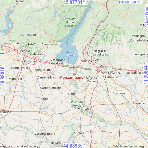
Monzambano GPS coordinates[2]
45° 23' 7.224" North, 10° 41' 35.916" East
| Map corner | latitude | longitude |
|---|---|---|
| Upper-left | 45.87701°, | 9.99018° |
| Center: | 45.38534°, | 10.69331° |
| Lower-right: | 44.88935°, | 11.39644° |
| Map W x H: | 109.8×109.8 km | = 68.2×68.2mi |
| max Lat: | 47.04031° ⇑30.2% North |
| Monzambano: | 45.38534° |
| min Lat: | ⇓69.8% South 35.50142° |
| min Long | Monzambano | max Long |
| 6.69888° | 10.69331° | 18.48682° |
| W 39%⇐ | ⇒61% E |
Elevation
Elevation of Monzambano is 79 m = 259 ft, and this is 227.7 m = 747 ft below average elevation for this country.
| Max E: |
2085 m = 6841 ft | 73.8% |
| Avg. | 306.7 m = 1006 ft | |
| Monzambano | 79 m = 259 ft | |
Min E: |
-4 m = -13 ft | 26.2% |
See also: Italy elevation on elevation.city.
Geographical zone
Monzambano is located in North temperate zone (between Tropic of Cancer and the Arctic Circle). Distance of this North polar circle is 2354.8 km =1463.2 mi to North.| Distance of | km | miles | from Monzambano |
|---|---|---|---|
| North Pole | 4960.7 | 3082.4 | to North |
| Arctic Circle | 2354.8 | 1463.2 | to North |
| Tropic Cancer | 2440.5 | 1516.5 | to South |
| Equator | 5046.4 | 3135.7 | to South |


Nearby cities:
15 places around Monzambano: (largest is in red/bold)
• Castelnuovo del Garda
7.9 km =4.9 mi,  41°
41°
• Cavalcaselle
6.3 km =3.9 mi,  24°
24°
• Cavriana
8.7 km =5.4 mi,  241°
241°
• Custoza
8.1 km =5 mi,  96°
96°
• Peschiera del Garda
6 km =3.7 mi,  354°
354°
• Ponti sul Mincio
3 km =1.9 mi, 347°
• Pozzolengo
5.4 km =3.4 mi,  294°
294°
• Pozzolo
9.4 km =5.8 mi,  168°
168°
• Quaderni
9.8 km =6.1 mi,  129°
129°
• Salionze
3.2 km =2 mi,  46°
46°
• San Giorgio in Salici
8.8 km =5.5 mi,  58°
58°
• San Martino della Battaglia
9.3 km =5.8 mi,  309°
309°
• Valeggio sul Mincio
4.9 km =3 mi,  136°
136°
• Volta Mantovana
7.5 km =4.7 mi,  200°
200°
• Zona Artigianale Foroni
6 km =3.7 mi,  147°
147°
Sources, notices
• [Note1] Compared only with cities in Italy existing in our database
• [Src1] Map data: © OpenStreetMap contributors (CC-BY-SA)
• [Src2] Other city data from geonames.org with taken over terms of usage.
• [Src3] Geographical zone / Annual Mean Temperature by Robert A. Rohde @ Wikipedia
