San Giorgio in Salici geodata
San Giorgio in Salici (Veneto) is a populated place; located in Italy in Europe/Rome (GMT+2) time zone. With population of 1,396 people, there are 5371 cities with bigger population in this country. Compared to other cities in Italy, 71.1% of cities are located further ↓South; 59.8% of cities are located further →East and 62.9% of cities have higher elevation than San Giorgio in Salici. Note1
Current local time in San Giorgio in Salici:
09:37 PM, WednesdayDifference from your time zone: hours


San Giorgio in Salici GPS coordinates[2]
45° 25' 36.336" North, 10° 47' 20.616" East
| Map corner | latitude | longitude |
|---|---|---|
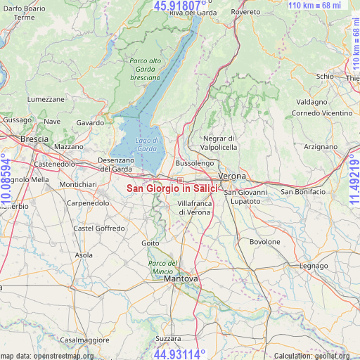
| Upper-left | 45.91807°, | 10.08594° |
| Center: | 45.42676°, | 10.78906° |
| Lower-right: | 44.93114°, | 11.49219° |
| Map W x H: | 109.7×109.7 km | = 68.2×68.2mi |
| max Lat: | 47.04031° ⇑28.9% North |
| San Giorgio in Salici: | 45.42676° |
| min Lat: | ⇓71.1% South 35.50142° |
| min Long | San Giorgio in | max Long |
| 6.69888° | 10.78906° | 18.48682° |
| W 40.2%⇐ | ⇒59.8% E |
Elevation
Elevation of San Giorgio in Salici is 142 m = 466 ft, and this is 164.7 m = 540 ft below average elevation for this country.
| Max E: |
2085 m = 6841 ft | 62.9% |
| Avg. | 306.7 m = 1006 ft | |
| San Giorgio in Salici | 142 m = 466 ft | |
Min E: |
-4 m = -13 ft | 37.1% |
See also: Italy elevation on elevation.city.
Geographical zone
San Giorgio in Salici is located in North temperate zone (between Tropic of Cancer and the Arctic Circle). Distance of this North polar circle is 2350.2 km =1460.3 mi to North.| Distance of | km | miles | from San Giorgio in Salici |
|---|---|---|---|
| North Pole | 4956.1 | 3079.6 | to North |
| Arctic Circle | 2350.2 | 1460.3 | to North |
| Tropic Cancer | 2445.1 | 1519.3 | to South |
| Equator | 5051 | 3138.5 | to South |


Nearby cities:
15 places around San Giorgio in Salici: (largest is in red/bold)
• Bussolengo
6.9 km =4.3 mi,  47°
47°
• Caselle
8.5 km =5.3 mi,  100°
100°
• Castelnuovo del Garda
2.6 km =1.6 mi,  300°
300°
• Cavalcaselle
5 km =3.1 mi,  283°
283°
• Colà
6.4 km =4 mi,  325°
325°
• Custoza
5.5 km =3.4 mi,  173°
173°
• Lugagnano
7.4 km =4.6 mi,  84°
84°
• Pastrengo
7.7 km =4.8 mi,  5°
5°
• Peschiera del Garda
8.1 km =5 mi, 279°
• Ponti sul Mincio
8.3 km =5.2 mi,  258°
258°
• Salionze
5.7 km =3.5 mi,  244°
244°
• Sandrà
3.8 km =2.4 mi,  357°
357°
• Sommacampagna
4.9 km =3 mi,  119°
119°
• Sona
4 km =2.5 mi, 80°
• Via Pastrengo
6.3 km =3.9 mi,  29°
29°
Sources, notices
• [Note1] Compared only with cities in Italy existing in our database
• [Src1] Map data: © OpenStreetMap contributors (CC-BY-SA)
• [Src2] Other city data from geonames.org with taken over terms of usage.
• [Src3] Geographical zone / Annual Mean Temperature by Robert A. Rohde @ Wikipedia
