Montottone geodata
Montottone (The Marches) is a seat of a third-order administrative division; located in Italy in Europe/Rome (GMT+2) time zone. With population of 522 people, there are 9714 cities with bigger population in this country. Compared to other cities in Italy, 62.9% of cities are located further ↑North; 74.5% of cities are located further ←West and 54.1% of cities have lower elevation than Montottone. Note1


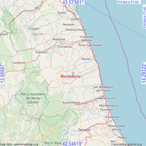
Montottone GPS coordinates[2]
43° 3' 43.38" North, 13° 35' 24.324" East
| Map corner | latitude | longitude |
|---|---|---|
| Upper-left | 43.57361°, | 12.88697° |
| Center: | 43.06205°, | 13.59009° |
| Lower-right: | 42.54619°, | 14.29322° |
| Map W x H: | 114.2×114.2 km | = 71×71mi |
| max Lat: | 47.04031° ⇑62.9% North |
| Montottone: | 43.06205° |
| min Lat: | ⇓37.1% South 35.50142° |
| min Long | Montottone | max Long |
| 6.69888° | 13.59009° | 18.48682° |
| W 74.5%⇐ | ⇒25.5% E |
Elevation
Elevation of Montottone is 260 m = 853 ft, and this is 46.7 m = 153 ft below average elevation for this country.
| Max E: |
2085 m = 6841 ft | 45.9% |
| Avg. | 306.7 m = 1006 ft | |
| Montottone | 260 m = 853 ft | |
Min E: |
-4 m = -13 ft | 54.1% |
See also: Italy elevation on elevation.city.
Geographical zone
Montottone is located in North temperate zone (between Tropic of Cancer and the Arctic Circle). Distance of this Northern Tropic circle is 2182.1 km =1355.9 mi to South.| Distance of | km | miles | from Montottone |
|---|---|---|---|
| North Pole | 5219 | 3242.9 | to North |
| Arctic Circle | 2613.1 | 1623.7 | to North |
| Tropic Cancer | 2182.1 | 1355.9 | to South |
| Equator | 4788.1 | 2975.2 | to South |


Nearby cities:
15 places around Montottone: (largest is in red/bold)
• Belmonte Piceno
5.3 km =3.3 mi,  308°
308°
• Capparuccia
8.1 km =5 mi,  20°
20°
• Grottazzolina
6.5 km =4 mi,  12°
12°
• Monsampietro Morico
2.9 km =1.8 mi,  282°
282°
• Montalto delle Marche
8.2 km =5.1 mi,  169°
169°
• Monte Giberto
4.6 km =2.9 mi,  46°
46°
• Monte Rinaldo
3.8 km =2.4 mi,  189°
189°
• Monte Vidon Combatte
3.6 km =2.2 mi,  113°
113°
• Monteleone di Fermo
5.2 km =3.2 mi,  252°
252°
• Montelparo
6.6 km =4.1 mi,  221°
221°
• Ortezzano
3.7 km =2.3 mi,  160°
160°
• Petritoli
6 km =3.7 mi,  83°
83°
• Piane di Montegiorgio
6.3 km =3.9 mi,  342°
342°
• Ponzano di Fermo
7.3 km =4.5 mi, 50°
• Servigliano
8.2 km =5.1 mi, 284°
Sources, notices
• [Note1] Compared only with cities in Italy existing in our database
• [Src1] Map data: © OpenStreetMap contributors (CC-BY-SA)
• [Src2] Other city data from geonames.org with taken over terms of usage.
• [Src3] Geographical zone / Annual Mean Temperature by Robert A. Rohde @ Wikipedia
