Servigliano geodata
Servigliano (The Marches) is a seat of a third-order administrative division; located in Italy in Europe/Rome (GMT+2) time zone. With population of 1,431 people, there are 5291 cities with bigger population in this country. Compared to other cities in Italy, 62.7% of cities are located further ↑North; 73.5% of cities are located further ←West and 52.5% of cities have higher elevation than Servigliano. Note1


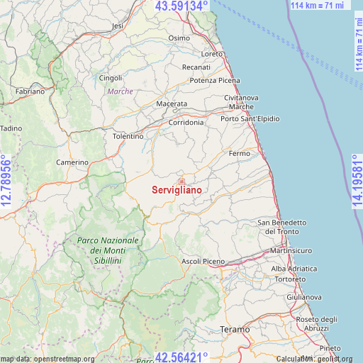
Servigliano GPS coordinates[2]
43° 4' 47.748" North, 13° 29' 33.648" East
| Map corner | latitude | longitude |
|---|---|---|
| Upper-left | 43.59134°, | 12.78956° |
| Center: | 43.07993°, | 13.49268° |
| Lower-right: | 42.56421°, | 14.19581° |
| Map W x H: | 114.2×114.2 km | = 71×71mi |
| max Lat: | 47.04031° ⇑62.7% North |
| Servigliano: | 43.07993° |
| min Lat: | ⇓37.3% South 35.50142° |
| min Long | Servigliano | max Long |
| 6.69888° | 13.49268° | 18.48682° |
| W 73.5%⇐ | ⇒26.5% E |
Elevation
Elevation of Servigliano is 219 m = 719 ft, and this is 87.7 m = 288 ft below average elevation for this country.
| Max E: |
2085 m = 6841 ft | 52.5% |
| Avg. | 306.7 m = 1006 ft | |
| Servigliano | 219 m = 719 ft | |
Min E: |
-4 m = -13 ft | 47.5% |
See also: Italy elevation on elevation.city.
Geographical zone
Servigliano is located in North temperate zone (between Tropic of Cancer and the Arctic Circle). Distance of this Northern Tropic circle is 2184.1 km =1357.1 mi to South.| Distance of | km | miles | from Servigliano |
|---|---|---|---|
| North Pole | 5217 | 3241.7 | to North |
| Arctic Circle | 2611.1 | 1622.5 | to North |
| Tropic Cancer | 2184.1 | 1357.1 | to South |
| Equator | 4790 | 2976.4 | to South |


Nearby cities:
15 places around Servigliano: (largest is in red/bold)
• Belmonte Piceno
4 km =2.5 mi,  70°
70°
• Falerone
3.2 km =2 mi,  328°
328°
• Massa Fermana
7.6 km =4.7 mi,  349°
349°
• Monsampietro Morico
5.3 km =3.3 mi,  104°
104°
• Montappone
6.5 km =4 mi,  343°
343°
• Monte San Martino
6.8 km =4.2 mi,  218°
218°
• Monte Vidon Combatte
6.2 km =3.9 mi,  213°
213°
• Monte Vidon Corrado
4.6 km =2.9 mi,  356°
356°
• Montegiorgio
6.7 km =4.2 mi,  34°
34°
• Monteleone di Fermo
4.7 km =2.9 mi,  140°
140°
• Montelparo
7.8 km =4.8 mi,  152°
152°
• Penna San Giovanni
6.1 km =3.8 mi,  244°
244°
• Piane
1.9 km =1.2 mi,  5°
5°
• Piane di Montegiorgio
7.2 km =4.5 mi,  56°
56°
• San Vittoria in Matenano
6.7 km =4.2 mi,  177°
177°
Sources, notices
• [Note1] Compared only with cities in Italy existing in our database
• [Src1] Map data: © OpenStreetMap contributors (CC-BY-SA)
• [Src2] Other city data from geonames.org with taken over terms of usage.
• [Src3] Geographical zone / Annual Mean Temperature by Robert A. Rohde @ Wikipedia
