Monte Urano geodata
Monte Urano (The Marches) is a seat of a third-order administrative division; located in Italy in Europe/Rome (GMT+2) time zone. With population of 6,527 people, there are 1495 cities with bigger population in this country. Compared to other cities in Italy, 61.8% of cities are located further ↑North; 75.2% of cities are located further ←West and 56.8% of cities have higher elevation than Monte Urano. Note1


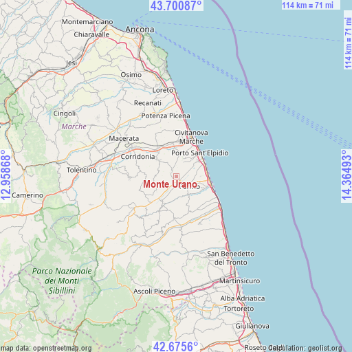
Monte Urano GPS coordinates[2]
43° 11' 25.404" North, 13° 39' 42.48" East
| Map corner | latitude | longitude |
|---|---|---|
| Upper-left | 43.70087°, | 12.95868° |
| Center: | 43.19039°, | 13.6618° |
| Lower-right: | 42.6756°, | 14.36493° |
| Map W x H: | 114×114 km | = 70.8×70.8mi |
| max Lat: | 47.04031° ⇑61.8% North |
| Monte Urano: | 43.19039° |
| min Lat: | ⇓38.2% South 35.50142° |
| min Long | Monte Urano | max Long |
| 6.69888° | 13.6618° | 18.48682° |
| W 75.2%⇐ | ⇒24.8% E |
Elevation
Elevation of Monte Urano is 189 m = 620 ft, and this is 117.7 m = 386 ft below average elevation for this country.
| Max E: |
2085 m = 6841 ft | 56.8% |
| Avg. | 306.7 m = 1006 ft | |
| Monte Urano | 189 m = 620 ft | |
Min E: |
-4 m = -13 ft | 43.2% |
See also: Italy elevation on elevation.city.
Geographical zone
Monte Urano is located in North temperate zone (between Tropic of Cancer and the Arctic Circle). Distance of this Northern Tropic circle is 2196.4 km =1364.8 mi to South.| Distance of | km | miles | from Monte Urano |
|---|---|---|---|
| North Pole | 5204.7 | 3234 | to North |
| Arctic Circle | 2598.9 | 1614.9 | to North |
| Tropic Cancer | 2196.4 | 1364.8 | to South |
| Equator | 4802.3 | 2984 | to South |


Nearby cities:
15 places around Monte Urano: (largest is in red/bold)
• Campiglione
1.7 km =1.1 mi,  155°
155°
• Capparuccia
7.3 km =4.5 mi,  203°
203°
• Casette d'Ete
7.3 km =4.5 mi,  13°
13°
• Cretarola
7.7 km =4.8 mi,  52°
52°
• Fermo
5.8 km =3.6 mi,  121°
121°
• La Luce
5.1 km =3.2 mi,  64°
64°
• Molini di Tenna
2.8 km =1.7 mi, 163°
• Monte San Giusto
7.5 km =4.7 mi,  312°
312°
• Monte San Pietrangeli
6.9 km =4.3 mi,  269°
269°
• Montegranaro
5.2 km =3.2 mi,  330°
330°
• Ponte Ete-Caldarette
7.3 km =4.5 mi,  141°
141°
• Rapagnano
6.8 km =4.2 mi,  240°
240°
• San Marco
7.5 km =4.7 mi,  72°
72°
• Sant'Elpidio a Mare
4.9 km =3 mi,  25°
25°
• Torre San Patrizio
4.2 km =2.6 mi,  258°
258°
Sources, notices
• [Note1] Compared only with cities in Italy existing in our database
• [Src1] Map data: © OpenStreetMap contributors (CC-BY-SA)
• [Src2] Other city data from geonames.org with taken over terms of usage.
• [Src3] Geographical zone / Annual Mean Temperature by Robert A. Rohde @ Wikipedia
