La Luce geodata
La Luce (The Marches) is a populated place; located in Italy in Europe/Rome (GMT+2) time zone. With population of 683 people, there are 8407 cities with bigger population in this country. Compared to other cities in Italy, 61.8% of cities are located further ↑North; 75.8% of cities are located further ←West and 82.9% of cities have higher elevation than La Luce. Note1
Administrative division(s):
- Level 1: The Marches
- Level 2: Province of Fermo
- Level 3: Sant'Elpidio a Mare


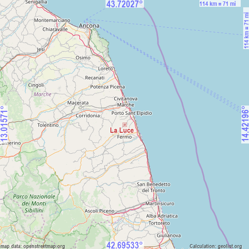
La Luce GPS coordinates[2]
43° 12' 35.82" North, 13° 43' 7.788" East
| Map corner | latitude | longitude |
|---|---|---|
| Upper-left | 43.72027°, | 13.01571° |
| Center: | 43.20995°, | 13.71883° |
| Lower-right: | 42.69533°, | 14.42196° |
| Map W x H: | 114×114 km | = 70.8×70.8mi |
| max Lat: | 47.04031° ⇑61.8% North |
| La Luce: | 43.20995° |
| min Lat: | ⇓38.2% South 35.50142° |
| min Long | La Luce | max Long |
| 6.69888° | 13.71883° | 18.48682° |
| W 75.8%⇐ | ⇒24.2% E |
Elevation
Elevation of La Luce is 38 m = 125 ft, and this is 268.7 m = 882 ft below average elevation for this country.
| Max E: |
2085 m = 6841 ft | 82.9% |
| Avg. | 306.7 m = 1006 ft | |
| La Luce | 38 m = 125 ft | |
Min E: |
-4 m = -13 ft | 17.1% |
See also: Italy elevation on elevation.city.
Geographical zone
La Luce is located in North temperate zone (between Tropic of Cancer and the Arctic Circle). Distance of this Northern Tropic circle is 2198.6 km =1366.1 mi to South.| Distance of | km | miles | from La Luce |
|---|---|---|---|
| North Pole | 5202.6 | 3232.7 | to North |
| Arctic Circle | 2596.7 | 1613.5 | to North |
| Tropic Cancer | 2198.6 | 1366.1 | to South |
| Equator | 4804.5 | 2985.4 | to South |


Nearby cities:
15 places around La Luce: (largest is in red/bold)
• Bivio Strada Vecchia
4.8 km =3 mi,  24°
24°
• Campiglione
5.4 km =3.4 mi,  226°
226°
• Capodarco
4 km =2.5 mi,  124°
124°
• Cascinare
6.1 km =3.8 mi,  354°
354°
• Casette d'Ete
5.7 km =3.5 mi,  329°
329°
• Castellano
5.9 km =3.7 mi,  1°
1°
• Cretarola
2.9 km =1.8 mi,  30°
30°
• Fermo
5.2 km =3.2 mi,  176°
176°
• Lido di Fermo
5.4 km =3.4 mi,  95°
95°
• Molini di Tenna
6.2 km =3.9 mi,  218°
218°
• Monte Urano
5.1 km =3.2 mi,  244°
244°
• Porto Sant'Elpidio
5.8 km =3.6 mi, 34°
• San Marco
2.5 km =1.6 mi,  88°
88°
• San Tommaso Tre Archi
5 km =3.1 mi,  66°
66°
• Sant'Elpidio a Mare
3.4 km =2.1 mi,  312°
312°
Sources, notices
• [Note1] Compared only with cities in Italy existing in our database
• [Src1] Map data: © OpenStreetMap contributors (CC-BY-SA)
• [Src2] Other city data from geonames.org with taken over terms of usage.
• [Src3] Geographical zone / Annual Mean Temperature by Robert A. Rohde @ Wikipedia
