Monterotondo geodata
Monterotondo (Latium) is a seat of a third-order administrative division; located in Italy in Europe/Rome (GMT+2) time zone. With population of 37,225 people, there are 199 cities with bigger population in this country. Compared to other cities in Italy, 69.9% of cities are located further ↑North; 63.9% of cities are located further ←West and 63% of cities have higher elevation than Monterotondo. Note1
Administrative division(s):
- Level 1: Latium
- Level 2: Città metropolitana di Roma Capitale
- Level 3: Monterotondo


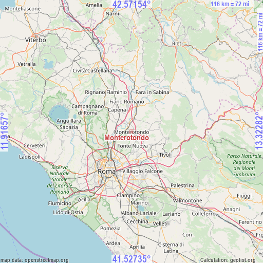
Monterotondo GPS coordinates[2]
42° 3' 5.724" North, 12° 37' 10.884" East
| Map corner | latitude | longitude |
|---|---|---|
| Upper-left | 42.57154°, | 11.91657° |
| Center: | 42.05159°, | 12.61969° |
| Lower-right: | 41.52735°, | 13.32282° |
| Map W x H: | 116.1×116.1 km | = 72.1×72.1mi |
| max Lat: | 47.04031° ⇑69.9% North |
| Monterotondo: | 42.05159° |
| min Lat: | ⇓30.1% South 35.50142° |
| min Long | Monterotondo | max Long |
| 6.69888° | 12.61969° | 18.48682° |
| W 63.9%⇐ | ⇒36.1% E |
Elevation
Elevation of Monterotondo is 141 m = 463 ft, and this is 165.7 m = 544 ft below average elevation for this country.
| Max E: |
2085 m = 6841 ft | 63% |
| Avg. | 306.7 m = 1006 ft | |
| Monterotondo | 141 m = 463 ft | |
Min E: |
-4 m = -13 ft | 37% |
See also: Italy elevation on elevation.city.
Geographical zone
Monterotondo is located in North temperate zone (between Tropic of Cancer and the Arctic Circle). Distance of this Northern Tropic circle is 2069.8 km =1286.1 mi to South.| Distance of | km | miles | from Monterotondo |
|---|---|---|---|
| North Pole | 5331.4 | 3312.8 | to North |
| Arctic Circle | 2725.5 | 1693.5 | to North |
| Tropic Cancer | 2069.8 | 1286.1 | to South |
| Equator | 4675.7 | 2905.3 | to South |


Nearby cities:
15 places around Monterotondo: (largest is in red/bold)
• Andreuzza
6.9 km =4.3 mi,  130°
130°
• Bivio di Capanelle
7.9 km =4.9 mi,  344°
344°
• Castel Chiodato
6.5 km =4 mi,  85°
85°
• Colle Verde
8.3 km =5.2 mi,  180°
180°
• Colleverde II
8.5 km =5.3 mi,  173°
173°
• Costaroni
7.4 km =4.6 mi,  293°
293°
• Cretone
7.3 km =4.5 mi,  72°
72°
• Girardi-Bellavista-Terrazze
6.6 km =4.1 mi,  329°
329°
• Mentana
2.7 km =1.7 mi, 131°
• Pichini
7.6 km =4.7 mi,  136°
136°
• San Martino-Sant'Anzino
3.2 km =2 mi,  347°
347°
• Sant'Angelo Romano
7.9 km =4.9 mi,  102°
102°
• Santa Lucia
8.3 km =5.2 mi,  158°
158°
• Tor Lupara
6 km =3.7 mi, 181°
• Tre Pontoni
7.4 km =4.6 mi,  322°
322°
Sources, notices
• [Note1] Compared only with cities in Italy existing in our database
• [Src1] Map data: © OpenStreetMap contributors (CC-BY-SA)
• [Src2] Other city data from geonames.org with taken over terms of usage.
• [Src3] Geographical zone / Annual Mean Temperature by Robert A. Rohde @ Wikipedia
