Montasola geodata
Montasola (Latium) is a seat of a third-order administrative division; located in Italy in Europe/Rome (GMT+2) time zone. With population of 79 people, there are 11512 cities with bigger population in this country. Compared to other cities in Italy, 67% of cities are located further ↑North; 64.7% of cities are located further ←West and 83.2% of cities have lower elevation than Montasola. Note1


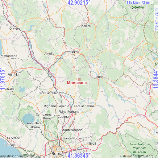
Montasola GPS coordinates[2]
42° 23' 5.82" North, 12° 40' 52.572" East
| Map corner | latitude | longitude |
|---|---|---|
| Upper-left | 42.90215°, | 11.97815° |
| Center: | 42.38495°, | 12.68127° |
| Lower-right: | 41.86345°, | 13.3844° |
| Map W x H: | 115.5×115.5 km | = 71.8×71.8mi |
| max Lat: | 47.04031° ⇑67% North |
| Montasola: | 42.38495° |
| min Lat: | ⇓33% South 35.50142° |
| min Long | Montasola | max Long |
| 6.69888° | 12.68127° | 18.48682° |
| W 64.7%⇐ | ⇒35.3% E |
Elevation
Elevation of Montasola is 575 m = 1886 ft, and this is 268.3 m = 880 ft above average elevation for this country.
| Max E: |
2085 m = 6841 ft | 16.8% |
| Montasola | 575 m 1886 ft | |
| Avg. | 306.7 m = 1006 ft | |
Min E: |
-4 m = -13 ft | 83.2% |
See also: Italy elevation on elevation.city.
Geographical zone
Montasola is located in North temperate zone (between Tropic of Cancer and the Arctic Circle). Distance of this Northern Tropic circle is 2106.8 km =1309.1 mi to South.| Distance of | km | miles | from Montasola |
|---|---|---|---|
| North Pole | 5294.3 | 3289.7 | to North |
| Arctic Circle | 2688.4 | 1670.5 | to North |
| Tropic Cancer | 2106.8 | 1309.1 | to South |
| Equator | 4712.8 | 2928.4 | to South |


Nearby cities:
15 places around Montasola: (largest is in red/bold)
• Calvi dell'Umbria
9.6 km =6 mi,  282°
282°
• Cantalupo in Sabina
9.2 km =5.7 mi,  198°
198°
• Casperia
5.2 km =3.2 mi,  190°
190°
• Configni
5.4 km =3.4 mi,  326°
326°
• Contigliano
8 km =5 mi,  69°
69°
• Cottanello
2.6 km =1.6 mi,  8°
8°
• Monte San Giovanni in Sabina
10.3 km =6.4 mi,  128°
128°
• Montebuono
7.2 km =4.5 mi,  254°
254°
• Piani Poggio Fidoni
9.4 km =5.8 mi,  84°
84°
• Poggio Catino
10.2 km =6.3 mi,  172°
172°
• Roccantica
7.2 km =4.5 mi, 171°
• Selci
10.4 km =6.5 mi,  208°
208°
• Tarano
7.8 km =4.8 mi, 245°
• Torri in Sabina
5 km =3.1 mi,  220°
220°
• Vacone
3 km =1.9 mi,  261°
261°
Sources, notices
• [Note1] Compared only with cities in Italy existing in our database
• [Src1] Map data: © OpenStreetMap contributors (CC-BY-SA)
• [Src2] Other city data from geonames.org with taken over terms of usage.
• [Src3] Geographical zone / Annual Mean Temperature by Robert A. Rohde @ Wikipedia
