Mongrando geodata
Mongrando (Piedmont) is a seat of a third-order administrative division; located in Italy in Europe/Rome (GMT+2) time zone. With population of 4,022 people, there are 2381 cities with bigger population in this country. Compared to other cities in Italy, 74.6% of cities are located further ↓South; 93.5% of cities are located further →East and 64.9% of cities have lower elevation than Mongrando. Note1


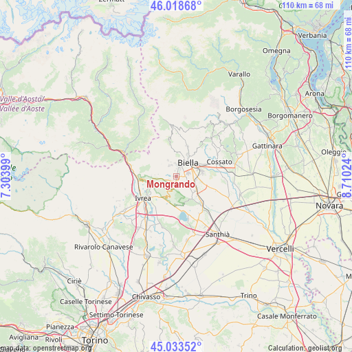
Mongrando GPS coordinates[2]
45° 31' 41.736" North, 8° 0' 25.632" East
| Map corner | latitude | longitude |
|---|---|---|
| Upper-left | 46.01868°, | 7.30399° |
| Center: | 45.52826°, | 8.00712° |
| Lower-right: | 45.03352°, | 8.71024° |
| Map W x H: | 109.5×109.5 km | = 68×68mi |
| max Lat: | 47.04031° ⇑25.4% North |
| Mongrando: | 45.52826° |
| min Lat: | ⇓74.6% South 35.50142° |
| min Long | Mongrando | max Long |
| 6.69888° | 8.00712° | 18.48682° |
| W 6.5%⇐ | ⇒93.5% E |
Elevation
Elevation of Mongrando is 342 m = 1122 ft, and this is 35.3 m = 116 ft above average elevation for this country.
| Max E: |
2085 m = 6841 ft | 35.1% |
| Mongrando | 342 m 1122 ft | |
| Avg. | 306.7 m = 1006 ft | |
Min E: |
-4 m = -13 ft | 64.9% |
See also: Italy elevation on elevation.city.
Geographical zone
Mongrando is located in North temperate zone (between Tropic of Cancer and the Arctic Circle). Distance of this North polar circle is 2338.9 km =1453.3 mi to North.| Distance of | km | miles | from Mongrando |
|---|---|---|---|
| North Pole | 4944.8 | 3072.6 | to North |
| Arctic Circle | 2338.9 | 1453.3 | to North |
| Tropic Cancer | 2456.3 | 1526.3 | to South |
| Equator | 5062.3 | 3145.6 | to South |


Nearby cities:
15 places around Mongrando: (largest is in red/bold)
• Biella
5.5 km =3.4 mi,  45°
45°
• Borriana
3.3 km =2.1 mi,  132°
132°
• Camburzano
1.8 km =1.1 mi,  347°
347°
• Ceresane-Curanuova
0.4 km =0.2 mi,  180°
180°
• Gaglianico
5.6 km =3.5 mi,  79°
79°
• Graglia
4 km =2.5 mi,  326°
326°
• Muzzano
3.9 km =2.4 mi,  338°
338°
• Netro
4.9 km =3 mi,  285°
285°
• Occhieppo Inferiore
2.7 km =1.7 mi,  24°
24°
• Occhieppo Superiore
4 km =2.5 mi,  358°
358°
• Ponderano
4 km =2.5 mi,  73°
73°
• Sala Biellese
4.4 km =2.7 mi,  240°
240°
• Sandigliano
5.5 km =3.4 mi,  97°
97°
• Torrazzo
5.3 km =3.3 mi,  231°
231°
• Zubiena
4.1 km =2.5 mi,  192°
192°
Sources, notices
• [Note1] Compared only with cities in Italy existing in our database
• [Src1] Map data: © OpenStreetMap contributors (CC-BY-SA)
• [Src2] Other city data from geonames.org with taken over terms of usage.
• [Src3] Geographical zone / Annual Mean Temperature by Robert A. Rohde @ Wikipedia
