Melegnano geodata
Melegnano (Lombardy) is a seat of a third-order administrative division; located in Italy in Europe/Rome (GMT+2) time zone. With population of 16,707 people, there are 536 cities with bigger population in this country. Compared to other cities in Italy, 69% of cities are located further ↓South; 75.9% of cities are located further →East and 70.2% of cities have higher elevation than Melegnano. Note1
Administrative division(s):
- Level 1: Lombardy
- Level 2: Città metropolitana di Milano
- Level 3: Melegnano


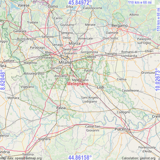
Melegnano GPS coordinates[2]
45° 21' 28.116" North, 9° 19' 24.96" East
| Map corner | latitude | longitude |
|---|---|---|
| Upper-left | 45.84972°, | 8.62048° |
| Center: | 45.35781°, | 9.3236° |
| Lower-right: | 44.86158°, | 10.02673° |
| Map W x H: | 109.9×109.9 km | = 68.3×68.3mi |
| max Lat: | 47.04031° ⇑31% North |
| Melegnano: | 45.35781° |
| min Lat: | ⇓69% South 35.50142° |
| min Long | Melegnano | max Long |
| 6.69888° | 9.3236° | 18.48682° |
| W 24.1%⇐ | ⇒75.9% E |
Elevation
Elevation of Melegnano is 96 m = 315 ft, and this is 210.7 m = 691 ft below average elevation for this country.
| Max E: |
2085 m = 6841 ft | 70.2% |
| Avg. | 306.7 m = 1006 ft | |
| Melegnano | 96 m = 315 ft | |
Min E: |
-4 m = -13 ft | 29.8% |
See also: Italy elevation on elevation.city.
Geographical zone
Melegnano is located in North temperate zone (between Tropic of Cancer and the Arctic Circle). Distance of this North polar circle is 2357.9 km =1465.1 mi to North.| Distance of | km | miles | from Melegnano |
|---|---|---|---|
| North Pole | 4963.7 | 3084.3 | to North |
| Arctic Circle | 2357.9 | 1465.1 | to North |
| Tropic Cancer | 2437.4 | 1514.5 | to South |
| Equator | 5043.3 | 3133.8 | to South |


Nearby cities:
15 places around Melegnano: (largest is in red/bold)
• Balbiano
3.7 km =2.3 mi,  44°
44°
• Carpiano
4.3 km =2.7 mi,  243°
243°
• Casalmaiocco
3.7 km =2.3 mi,  99°
99°
• Cerro al Lambro
3.3 km =2.1 mi,  158°
158°
• Colturano
2.8 km =1.7 mi,  17°
17°
• Dresano
3.2 km =2 mi,  57°
57°
• Madonnina e Cologno
3 km =1.9 mi,  76°
76°
• Mediglia
4.2 km =2.6 mi,  8°
8°
• Quartiere Sarmazzano
1.5 km =0.9 mi,  53°
53°
• Riozzo
1.3 km =0.8 mi,  186°
186°
• San Giuliano Milanese
4.8 km =3 mi,  327°
327°
• San Zenone al Lambro
4.3 km =2.7 mi,  143°
143°
• Sordio
3.6 km =2.2 mi,  118°
118°
• Triginto
4.9 km =3 mi,  1°
1°
• Vizzolo Predabissi
1.9 km =1.2 mi, 96°
Sources, notices
• [Note1] Compared only with cities in Italy existing in our database
• [Src1] Map data: © OpenStreetMap contributors (CC-BY-SA)
• [Src2] Other city data from geonames.org with taken over terms of usage.
• [Src3] Geographical zone / Annual Mean Temperature by Robert A. Rohde @ Wikipedia
