San Zenone al Lambro geodata
San Zenone al Lambro (Lombardy) is a seat of a third-order administrative division; located in Italy in Europe/Rome (GMT+2) time zone. With population of 3,203 people, there are 2896 cities with bigger population in this country. Compared to other cities in Italy, 68.1% of cities are located further ↓South; 75.4% of cities are located further →East and 72.8% of cities have higher elevation than San Zenone al Lambro. Note1
Administrative division(s):
- Level 1: Lombardy
- Level 2: Città metropolitana di Milano
- Level 3: San Zenone al Lambro
Current local time in San Zenone al Lambro:
08:31 PM, WednesdayDifference from your time zone: hours


San Zenone al Lambro GPS coordinates[2]
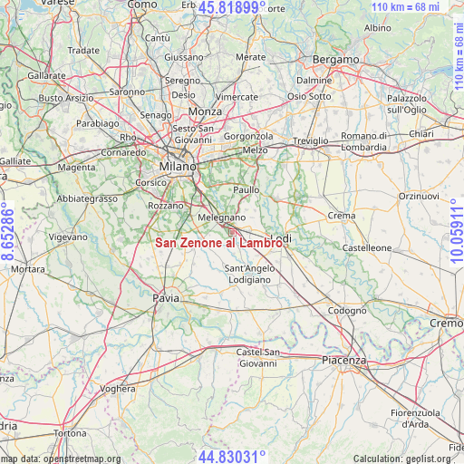
45° 19' 36.516" North, 9° 21' 21.528" East
| Map corner | latitude | longitude |
|---|---|---|
| Upper-left | 45.81899°, | 8.65286° |
| Center: | 45.32681°, | 9.35598° |
| Lower-right: | 44.83031°, | 10.05911° |
| Map W x H: | 109.9×109.9 km | = 68.3×68.3mi |
| max Lat: | 47.04031° ⇑31.9% North |
| San Zenone al Lambro: | 45.32681° |
| min Lat: | ⇓68.1% South 35.50142° |
| min Long | San Zenone al L | max Long |
| 6.69888° | 9.35598° | 18.48682° |
| W 24.6%⇐ | ⇒75.4% E |
Elevation
Elevation of San Zenone al Lambro is 84 m = 276 ft, and this is 222.7 m = 731 ft below average elevation for this country.
| Max E: |
2085 m = 6841 ft | 72.8% |
| Avg. | 306.7 m = 1006 ft | |
| San Zenone al Lambro | 84 m = 276 ft | |
Min E: |
-4 m = -13 ft | 27.2% |
See also: Italy elevation on elevation.city.
Geographical zone
San Zenone al Lambro is located in North temperate zone (between Tropic of Cancer and the Arctic Circle). Distance of this North polar circle is 2361.3 km =1467.2 mi to North.| Distance of | km | miles | from San Zenone al Lambro |
|---|---|---|---|
| North Pole | 4967.2 | 3086.5 | to North |
| Arctic Circle | 2361.3 | 1467.2 | to North |
| Tropic Cancer | 2433.9 | 1512.4 | to South |
| Equator | 5039.9 | 3131.6 | to South |


Nearby cities:
15 places around San Zenone al Lambro: (largest is in red/bold)
• Bascapè
4 km =2.5 mi,  234°
234°
• Casaletto Lodigiano
3.7 km =2.3 mi,  172°
172°
• Casalmaiocco
3.1 km =1.9 mi,  22°
22°
• Caselle Lurani
5.2 km =3.2 mi,  176°
176°
• Cerro al Lambro
1.4 km =0.9 mi,  284°
284°
• Dresano
5.1 km =3.2 mi,  1°
1°
• Madonnina e Cologno
4.2 km =2.6 mi,  5°
5°
• Mairano
1.9 km =1.2 mi, 172°
• Melegnano
4.3 km =2.7 mi,  323°
323°
• Quartiere Sarmazzano
4.6 km =2.9 mi,  343°
343°
• Riozzo
3.4 km =2.1 mi,  308°
308°
• Salerano sul Lambro
4.1 km =2.5 mi,  145°
145°
• Sordio
1.8 km =1.1 mi, 19°
• Tavazzano
3.8 km =2.4 mi,  88°
88°
• Vizzolo Predabissi
3.3 km =2.1 mi,  349°
349°
Sources, notices
• [Note1] Compared only with cities in Italy existing in our database
• [Src1] Map data: © OpenStreetMap contributors (CC-BY-SA)
• [Src2] Other city data from geonames.org with taken over terms of usage.
• [Src3] Geographical zone / Annual Mean Temperature by Robert A. Rohde @ Wikipedia
