Masserano geodata
Masserano (Piedmont) is a seat of a third-order administrative division; located in Italy in Europe/Rome (GMT+2) time zone. With population of 1,527 people, there are 5060 cities with bigger population in this country. Compared to other cities in Italy, 76.9% of cities are located further ↓South; 90.9% of cities are located further →East and 64.7% of cities have lower elevation than Masserano. Note1


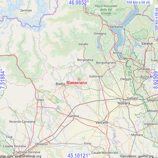
Masserano GPS coordinates[2]
45° 35' 43.296" North, 8° 13' 19.092" East
| Map corner | latitude | longitude |
|---|---|---|
| Upper-left | 46.0852°, | 7.51884° |
| Center: | 45.59536°, | 8.22197° |
| Lower-right: | 45.10121°, | 8.92509° |
| Map W x H: | 109.4×109.4 km | = 68×68mi |
| max Lat: | 47.04031° ⇑23.1% North |
| Masserano: | 45.59536° |
| min Lat: | ⇓76.9% South 35.50142° |
| min Long | Masserano | max Long |
| 6.69888° | 8.22197° | 18.48682° |
| W 9.1%⇐ | ⇒90.9% E |
Elevation
Elevation of Masserano is 340 m = 1115 ft, and this is 33.3 m = 109 ft above average elevation for this country.
| Max E: |
2085 m = 6841 ft | 35.3% |
| Masserano | 340 m 1115 ft | |
| Avg. | 306.7 m = 1006 ft | |
Min E: |
-4 m = -13 ft | 64.7% |
See also: Italy elevation on elevation.city.
Geographical zone
Masserano is located in North temperate zone (between Tropic of Cancer and the Arctic Circle). Distance of this North polar circle is 2331.4 km =1448.7 mi to North.| Distance of | km | miles | from Masserano |
|---|---|---|---|
| North Pole | 4937.3 | 3067.9 | to North |
| Arctic Circle | 2331.4 | 1448.7 | to North |
| Tropic Cancer | 2463.8 | 1530.9 | to South |
| Equator | 5069.7 | 3150.2 | to South |


Nearby cities:
15 places around Masserano: (largest is in red/bold)
• Brusnengo
2.4 km =1.5 mi,  103°
103°
• Capovilla-Castello
2 km =1.2 mi,  268°
268°
• Casapinta
3 km =1.9 mi,  318°
318°
• Cossato
4 km =2.5 mi,  226°
226°
• Curino
3.7 km =2.3 mi,  17°
17°
• Fontanella-Ozino
4.9 km =3 mi,  303°
303°
• Lanvario
5.3 km =3.3 mi,  339°
339°
• Lessona
2.3 km =1.4 mi,  246°
246°
• Mezzana Mortigliengo
4.3 km =2.7 mi, 323°
• Quaregna
4.8 km =3 mi, 250°
• Roasio
5 km =3.1 mi,  78°
78°
• San Maurizio
5.1 km =3.2 mi, 79°
• Sant'Eusebio
4 km =2.5 mi,  94°
94°
• Soprana
5.2 km =3.2 mi, 339°
• Villa del Bosco
4.9 km =3 mi,  61°
61°
Sources, notices
• [Note1] Compared only with cities in Italy existing in our database
• [Src1] Map data: © OpenStreetMap contributors (CC-BY-SA)
• [Src2] Other city data from geonames.org with taken over terms of usage.
• [Src3] Geographical zone / Annual Mean Temperature by Robert A. Rohde @ Wikipedia
