Curino geodata
Curino (Piedmont) is a seat of a third-order administrative division; located in Italy in Europe/Rome (GMT+2) time zone. With population of 475 people, there are 10005 cities with bigger population in this country. Compared to other cities in Italy, 78.1% of cities are located further ↓South; 90.7% of cities are located further →East and 66.6% of cities have lower elevation than Curino. Note1


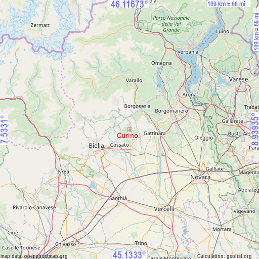
Curino GPS coordinates[2]
45° 37' 37.812" North, 8° 14' 10.392" East
| Map corner | latitude | longitude |
|---|---|---|
| Upper-left | 46.11673°, | 7.5331° |
| Center: | 45.62717°, | 8.23622° |
| Lower-right: | 45.1333°, | 8.93935° |
| Map W x H: | 109.3×109.3 km | = 67.9×67.9mi |
| max Lat: | 47.04031° ⇑21.9% North |
| Curino: | 45.62717° |
| min Lat: | ⇓78.1% South 35.50142° |
| min Long | Curino | max Long |
| 6.69888° | 8.23622° | 18.48682° |
| W 9.3%⇐ | ⇒90.7% E |
Elevation
Elevation of Curino is 359 m = 1178 ft, and this is 52.3 m = 172 ft above average elevation for this country.
| Max E: |
2085 m = 6841 ft | 33.4% |
| Curino | 359 m 1178 ft | |
| Avg. | 306.7 m = 1006 ft | |
Min E: |
-4 m = -13 ft | 66.6% |
See also: Italy elevation on elevation.city.
Geographical zone
Curino is located in North temperate zone (between Tropic of Cancer and the Arctic Circle). Distance of this North polar circle is 2327.9 km =1446.5 mi to North.| Distance of | km | miles | from Curino |
|---|---|---|---|
| North Pole | 4933.8 | 3065.7 | to North |
| Arctic Circle | 2327.9 | 1446.5 | to North |
| Tropic Cancer | 2467.3 | 1533.1 | to South |
| Equator | 5073.3 | 3152.4 | to South |


Nearby cities:
15 places around Curino: (largest is in red/bold)
• Brusnengo
4.3 km =2.7 mi,  163°
163°
• Capovilla-Castello
4.7 km =2.9 mi,  220°
220°
• Casapinta
3.4 km =2.1 mi,  247°
247°
• Fontanella-Ozino
5.3 km =3.3 mi,  260°
260°
• Lanvario
3.2 km =2 mi,  295°
295°
• Lessona
5.5 km =3.4 mi, 216°
• Masserano
3.7 km =2.3 mi,  197°
197°
• Mezzana Mortigliengo
3.6 km =2.2 mi,  268°
268°
• Pray
5.7 km =3.5 mi,  338°
338°
• Roasio
4.5 km =2.8 mi,  123°
123°
• San Maurizio
4.7 km =2.9 mi, 123°
• Sant'Eusebio
4.8 km =3 mi,  142°
142°
• Soprana
3.2 km =2 mi, 295°
• Sostegno
3.9 km =2.4 mi,  42°
42°
• Villa del Bosco
3.4 km =2.1 mi,  109°
109°
Sources, notices
• [Note1] Compared only with cities in Italy existing in our database
• [Src1] Map data: © OpenStreetMap contributors (CC-BY-SA)
• [Src2] Other city data from geonames.org with taken over terms of usage.
• [Src3] Geographical zone / Annual Mean Temperature by Robert A. Rohde @ Wikipedia
