Marcetelli geodata
Marcetelli (Latium) is a seat of a third-order administrative division; located in Italy in Europe/Rome (GMT+2) time zone. With population of 126 people, there are 11362 cities with bigger population in this country. Compared to other cities in Italy, 68.5% of cities are located further ↑North; 68.8% of cities are located further ←West and 96% of cities have lower elevation than Marcetelli. Note1


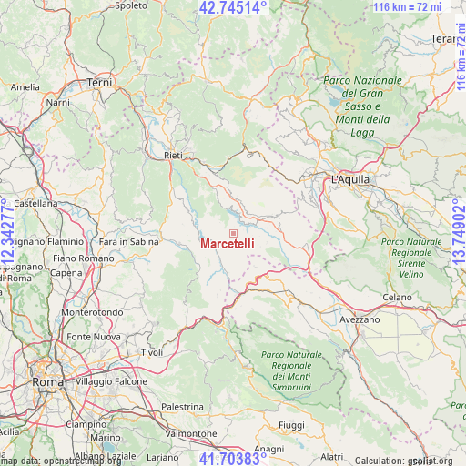
Marcetelli GPS coordinates[2]
42° 13' 35.868" North, 13° 2' 45.204" East
| Map corner | latitude | longitude |
|---|---|---|
| Upper-left | 42.74514°, | 12.34277° |
| Center: | 42.22663°, | 13.04589° |
| Lower-right: | 41.70383°, | 13.74902° |
| Map W x H: | 115.8×115.8 km | = 72×72mi |
| max Lat: | 47.04031° ⇑68.5% North |
| Marcetelli: | 42.22663° |
| min Lat: | ⇓31.5% South 35.50142° |
| min Long | Marcetelli | max Long |
| 6.69888° | 13.04589° | 18.48682° |
| W 68.8%⇐ | ⇒31.2% E |
Elevation
Elevation of Marcetelli is 932 m = 3058 ft, and this is 625.3 m = 2052 ft above average elevation for this country.
| Max E: |
2085 m = 6841 ft | 4% |
| Marcetelli | 932 m 3058 ft | |
| Avg. | 306.7 m = 1006 ft | |
Min E: |
-4 m = -13 ft | 96% |
See also: Italy elevation on elevation.city.
Geographical zone
Marcetelli is located in North temperate zone (between Tropic of Cancer and the Arctic Circle). Distance of this Northern Tropic circle is 2089.2 km =1298.2 mi to South.| Distance of | km | miles | from Marcetelli |
|---|---|---|---|
| North Pole | 5311.9 | 3300.7 | to North |
| Arctic Circle | 2706 | 1681.4 | to North |
| Tropic Cancer | 2089.2 | 1298.2 | to South |
| Equator | 4695.2 | 2917.5 | to South |


Nearby cities:
15 places around Marcetelli: (largest is in red/bold)
• Ascrea
5.3 km =3.3 mi,  232°
232°
• Castel di Tora
6.3 km =3.9 mi,  257°
257°
• Collalto Sabino
10.2 km =6.3 mi,  178°
178°
• Colle di Tora
8.4 km =5.2 mi, 255°
• Collegiove
5.8 km =3.6 mi,  186°
186°
• Fiamignano
7.8 km =4.8 mi,  56°
56°
• Longone Sabino
8.3 km =5.2 mi,  308°
308°
• Nespolo
8 km =5 mi,  166°
166°
• Paganico Sabino
5.8 km =3.6 mi,  224°
224°
• Pescorocchiano
8.6 km =5.3 mi,  105°
105°
• Petrella Salto
7.7 km =4.8 mi,  13°
13°
• Pozzaglia Sabino
10.1 km =6.3 mi, 221°
• Rocca Sinibalda
11.2 km =7 mi,  296°
296°
• Turania
10.6 km =6.6 mi,  196°
196°
• Varco Sabino
2.6 km =1.6 mi, 305°
Sources, notices
• [Note1] Compared only with cities in Italy existing in our database
• [Src1] Map data: © OpenStreetMap contributors (CC-BY-SA)
• [Src2] Other city data from geonames.org with taken over terms of usage.
• [Src3] Geographical zone / Annual Mean Temperature by Robert A. Rohde @ Wikipedia
