Manduria geodata
Manduria (Apulia) is a seat of a third-order administrative division; located in Italy in Europe/Rome (GMT+2) time zone. With population of 27,411 people, there are 292 cities with bigger population in this country. Compared to other cities in Italy, 84.8% of cities are located further ↑North; 98.7% of cities are located further ←West and 72.3% of cities have higher elevation than Manduria. Note1


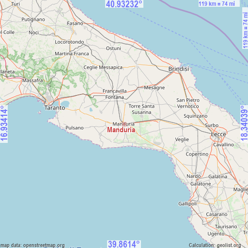
Manduria GPS coordinates[2]
40° 23' 56.364" North, 17° 38' 14.136" East
| Map corner | latitude | longitude |
|---|---|---|
| Upper-left | 40.93232°, | 16.93414° |
| Center: | 40.39899°, | 17.63726° |
| Lower-right: | 39.8614°, | 18.34039° |
| Map W x H: | 119.1×119.1 km | = 74×74mi |
| max Lat: | 47.04031° ⇑84.8% North |
| Manduria: | 40.39899° |
| min Lat: | ⇓15.2% South 35.50142° |
| min Long | Manduria | max Long |
| 6.69888° | 17.63726° | 18.48682° |
| W 98.7%⇐ | ⇒1.3% E |
Elevation
Elevation of Manduria is 86 m = 282 ft, and this is 220.7 m = 724 ft below average elevation for this country.
| Max E: |
2085 m = 6841 ft | 72.3% |
| Avg. | 306.7 m = 1006 ft | |
| Manduria | 86 m = 282 ft | |
Min E: |
-4 m = -13 ft | 27.7% |
See also: Italy elevation on elevation.city.
Geographical zone
Manduria is located in North temperate zone (between Tropic of Cancer and the Arctic Circle). Distance of this Northern Tropic circle is 1886 km =1171.9 mi to South.| Distance of | km | miles | from Manduria |
|---|---|---|---|
| North Pole | 5515.1 | 3426.9 | to North |
| Arctic Circle | 2909.2 | 1807.7 | to North |
| Tropic Cancer | 1886 | 1171.9 | to South |
| Equator | 4491.9 | 2791.1 | to South |


Nearby cities:
15 places around Manduria: (largest is in red/bold)
• Avetrana
9.7 km =6 mi,  123°
123°
• Erchie
9.3 km =5.8 mi,  63°
63°
• Fragagnano
14.1 km =8.8 mi,  284°
284°
• Francavilla Fontana
15.3 km =9.5 mi,  343°
343°
• Latiano
18.2 km =11.3 mi,  22°
22°
• Lizzano
16.2 km =10.1 mi,  267°
267°
• Maruggio
10.4 km =6.5 mi,  212°
212°
• Oria
11.2 km =7 mi,  2°
2°
• San Marzano di San Giuseppe
12.9 km =8 mi,  298°
298°
• San Pancrazio Salentino
16.8 km =10.4 mi,  82°
82°
• San Pietro Specchiarica
10.6 km =6.6 mi,  161°
161°
• Sava
7.2 km =4.5 mi, 272°
• Torre Santa Susanna
11.5 km =7.1 mi,  48°
48°
• Torricella
12.7 km =7.9 mi,  247°
247°
• Uggiano Montefusco
3.1 km =1.9 mi,  242°
242°
Sources, notices
• [Note1] Compared only with cities in Italy existing in our database
• [Src1] Map data: © OpenStreetMap contributors (CC-BY-SA)
• [Src2] Other city data from geonames.org with taken over terms of usage.
• [Src3] Geographical zone / Annual Mean Temperature by Robert A. Rohde @ Wikipedia
