Francavilla Fontana geodata
Francavilla Fontana (Apulia) is a seat of a third-order administrative division; located in Italy in Europe/Rome (GMT+2) time zone. With population of 33,415 people, there are 235 cities with bigger population in this country. Compared to other cities in Italy, 83.9% of cities are located further ↑North; 98.7% of cities are located further ←West and 62.4% of cities have higher elevation than Francavilla Fontana. Note1
Administrative division(s):
- Level 1: Apulia
- Level 2: Provincia di Brindisi
- Level 3: Francavilla Fontana


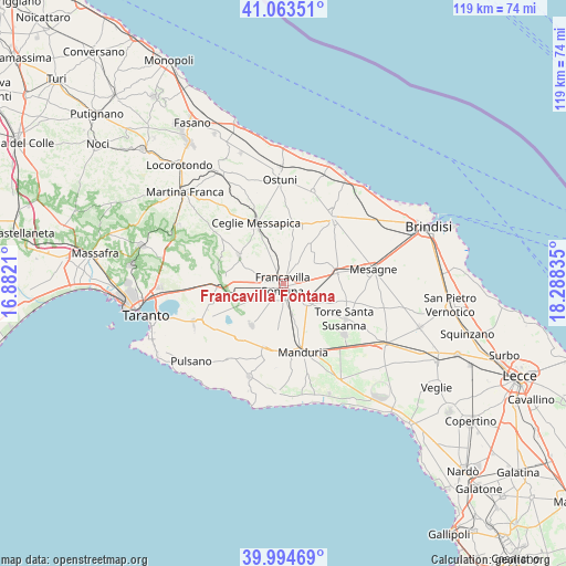
Francavilla Fontana GPS coordinates[2]
40° 31' 52.428" North, 17° 35' 6.792" East
| Map corner | latitude | longitude |
|---|---|---|
| Upper-left | 41.06351°, | 16.8821° |
| Center: | 40.53123°, | 17.58522° |
| Lower-right: | 39.99469°, | 18.28835° |
| Map W x H: | 118.8×118.8 km | = 73.8×73.8mi |
| max Lat: | 47.04031° ⇑83.9% North |
| Francavilla Fontana: | 40.53123° |
| min Lat: | ⇓16.1% South 35.50142° |
| min Long | Francavilla Fon | max Long |
| 6.69888° | 17.58522° | 18.48682° |
| W 98.7%⇐ | ⇒1.3% E |
Elevation
Elevation of Francavilla Fontana is 146 m = 479 ft, and this is 160.7 m = 527 ft below average elevation for this country.
| Max E: |
2085 m = 6841 ft | 62.4% |
| Avg. | 306.7 m = 1006 ft | |
| Francavilla Fontana | 146 m = 479 ft | |
Min E: |
-4 m = -13 ft | 37.6% |
See also: Italy elevation on elevation.city.
Geographical zone
Francavilla Fontana is located in North temperate zone (between Tropic of Cancer and the Arctic Circle). Distance of this Northern Tropic circle is 1900.7 km =1181 mi to South.| Distance of | km | miles | from Francavilla Fontana |
|---|---|---|---|
| North Pole | 5500.4 | 3417.8 | to North |
| Arctic Circle | 2894.5 | 1798.6 | to North |
| Tropic Cancer | 1900.7 | 1181 | to South |
| Equator | 4506.7 | 2800.3 | to South |


Nearby cities:
15 places around Francavilla Fontana: (largest is in red/bold)
• Carosino
17.4 km =10.8 mi,  245°
245°
• Ceglie Messapica
14 km =8.7 mi,  335°
335°
• Erchie
16.6 km =10.3 mi,  129°
129°
• Fragagnano
14.6 km =9.1 mi,  219°
219°
• Grottaglie
12.5 km =7.8 mi,  272°
272°
• Latiano
11.5 km =7.1 mi,  79°
79°
• Manduria
15.3 km =9.5 mi,  163°
163°
• Oria
6 km =3.7 mi, 125°
• San Marzano di San Giuseppe
11 km =6.8 mi, 219°
• San Michele Salentino
11.9 km =7.4 mi,  19°
19°
• San Vito dei Normanni
17.4 km =10.8 mi,  36°
36°
• Sava
14.6 km =9.1 mi,  190°
190°
• Torre Santa Susanna
14.8 km =9.2 mi,  118°
118°
• Uggiano Montefusco
16.2 km =10.1 mi,  174°
174°
• Villa Castelli
11 km =6.8 mi,  301°
301°
Sources, notices
• [Note1] Compared only with cities in Italy existing in our database
• [Src1] Map data: © OpenStreetMap contributors (CC-BY-SA)
• [Src2] Other city data from geonames.org with taken over terms of usage.
• [Src3] Geographical zone / Annual Mean Temperature by Robert A. Rohde @ Wikipedia
