Lovere geodata
Lovere (Lombardy) is a seat of a third-order administrative division; located in Italy in Europe/Rome (GMT+1) time zone. With population of 5,255 people, there are 1857 cities with bigger population in this country. Compared to other cities in Italy, 86.4% of cities are located further ↓South; 67.2% of cities are located further →East and 53.2% of cities have higher elevation than Lovere. Note1


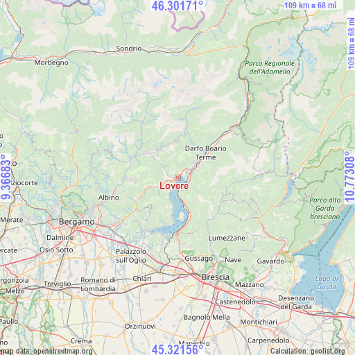
Lovere GPS coordinates[2]
45° 48' 49.644" North, 10° 4' 11.82" East
| Map corner | latitude | longitude |
|---|---|---|
| Upper-left | 46.30171°, | 9.36683° |
| Center: | 45.81379°, | 10.06995° |
| Lower-right: | 45.32156°, | 10.77308° |
| Map W x H: | 109×109 km | = 67.7×67.7mi |
| max Lat: | 47.04031° ⇑13.6% North |
| Lovere: | 45.81379° |
| min Lat: | ⇓86.4% South 35.50142° |
| min Long | Lovere | max Long |
| 6.69888° | 10.06995° | 18.48682° |
| W 32.8%⇐ | ⇒67.2% E |
Elevation
Elevation of Lovere is 215 m = 705 ft, and this is 91.7 m = 301 ft below average elevation for this country.
| Max E: |
2085 m = 6841 ft | 53.2% |
| Avg. | 306.7 m = 1006 ft | |
| Lovere | 215 m = 705 ft | |
Min E: |
-4 m = -13 ft | 46.8% |
See also: Italy elevation on elevation.city.
Geographical zone
Lovere is located in North temperate zone (between Tropic of Cancer and the Arctic Circle). Distance of this North polar circle is 2307.2 km =1433.6 mi to North.| Distance of | km | miles | from Lovere |
|---|---|---|---|
| North Pole | 4913 | 3052.8 | to North |
| Arctic Circle | 2307.2 | 1433.6 | to North |
| Tropic Cancer | 2488.1 | 1546 | to South |
| Equator | 5094 | 3165.3 | to South |


Nearby cities:
15 places around Lovere: (largest is in red/bold)
• Bossico
2.5 km =1.6 mi,  310°
310°
• Castro
1.2 km =0.7 mi,  195°
195°
• Costa Volpino
2.8 km =1.7 mi,  57°
57°
• Endine
7.8 km =4.8 mi,  249°
249°
• Fonteno
7.3 km =4.5 mi,  212°
212°
• Gratacasolo
4.9 km =3 mi,  69°
69°
• Pian Camuno
6.4 km =4 mi, 60°
• Piangaiano
6.5 km =4 mi,  244°
244°
• Pianico
2.1 km =1.3 mi,  258°
258°
• Pisogne
3.2 km =2 mi,  102°
102°
• Riva di Solto
5 km =3.1 mi, 208°
• Rogno
6.8 km =4.2 mi,  45°
45°
• Solto Collina
4.9 km =3 mi,  223°
223°
• Sovere
2.8 km =1.7 mi,  265°
265°
• Zone
6.6 km =4.1 mi,  147°
147°
Sources, notices
• [Note1] Compared only with cities in Italy existing in our database
• [Src1] Map data: © OpenStreetMap contributors (CC-BY-SA)
• [Src2] Other city data from geonames.org with taken over terms of usage.
• [Src3] Geographical zone / Annual Mean Temperature by Robert A. Rohde @ Wikipedia
